

Typhoon Phanfone Spreads Heavy Rain, Wind Across Japan
Kansas City, October 5 (World Weather Inc.) – Typhoon Phanfone was spreading rain and strong wind into Japan today and will race across the nation by Monday morning (U.S. time) and will move quickly to the east away from the area the remainder of Monday and Tuesday while diminishing. Heavy rain and strong wind will impact much of the main islands of Japan today, although Shikoku and Honshu will be most impacted. Some rice damage is possible and there is some potential for some citrus fruit droppage among other crop and property losses.
The center of Typhoon Phanfone at 0900 GMT today was located 445 miles west southwest of Tokyo, Japan at 32.0 north, 132.8 east. Movement was north northeasterly at 15 mph and maximum sustained wind speeds were reaching 104 mph making the storm a Category 1 hurricane equivalent system. Typhoon force wind (greater than 74mph) was occurring out 50 miles from the center of the storm while speeds of tropical storm force (greater than 40 mph) were occurring out 120 miles.
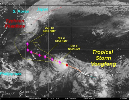 Rain and windy conditions have already commenced across a large part of western Japan and as the storm accelerates to the northeast today the adverse conditions will expand across a much larger portion of Japan. However, the storm’s fast movement will reduce the number of hours that the worst conditions exist and that will help to minimize some of the potential damage. The center of the storm was expected to pass over Tokyo tonight (U.S. time) around 0001 GMT, Oct. 6. The storm will produce 3.00 to 7.00 inches of rain across many areas from Kyushu through Shikoku and Honshu before exiting southeastern Honshu Monday. The storm will continue to race away from the region Monday and Tuesday while losing its tropical characteristics. Wind speeds will be greatest along the southern coast of Honshu today with speeds varying from 75 to 95 mph. Damage to some structures and crops is possible, although the damage is expected to be kept low by the weakening trend in the storm and its accelerated forward movement.
Some damage to rice and citrus is possible from the storm. Rice is maturing and being harvested and heavy rain can knock the maturing crop to the ground making it unharvestable. Farmers have had a few days’ notice of the impending storm and most have likely harvested the most mature grain and that should help to reduce production losses. The quick return of drier weather Tuesday will also help to protect unharvested rice quality. Some citrus fruit droppage is possible, although most of the greatest wind will be near the Honshu coast and not in the key production areas minimizing the potential for much loss.
In the meantime, Typhoon Vongfong was located 176 miles east of Guam at 13.7 north, 147.1 east at 0900 GMT today. Movement was west northwesterly at 24 mph and maximum sustained wind speeds were reaching 104 mph. Typhoon force wind (greater than 74 mph) was occurring out 30 miles from the center of the storm while tropical storm force wind (greater than 40 mph) was occurring out 115 miles from the center of the storm.
Vongfong will steadily intensify and will become a Category Four hurricane equivalent storm by Monday afternoon. The system will continue moving west northwesterly into mid-week, but a turn to the north and eventually to the northeast will occur during the second half of this week. The storm may eventually be a threat to Japan and it will need to be closely monitored. The system may turn to the northeast soon enough to avoid another impact on Japan like that of Typhoon Phanfone.
[info]World Weather, Inc. forecasts and comments pertaining to present, past and future weather conditions included in this report constitute the corporation’s judgment as of the date of this report and are subject to change without notice. Comments regarding damage or the impact of weather on agricultural and energy as well as comments made regarding the impact of weather on the commodity and financial markets are the explicit opinions of World Weather, Inc. World Weather, Inc. cannot be held responsible for decisions made by users of the Corporation’s information in any business, trade or investment decision. ©2014 World Weather, Inc. Any unauthorized redistribution, duplication or disclosure is prohibited by law and will result in prosecution.[/info]