

Sudden Winter Weather Stressing Livestock, Delaying Travel
Kansas City, November 10 (World Weather Inc.) – Unseasonably cold air moving south from Canada into the northern U.S. Plains Sunday and early today resulted in some extreme winter weather conditions at a time when winter crops and livestock might not have been well prepared. Stress to livestock was suspected of being extreme late Sunday and overnight last night and travel delays have developed in many areas from Montana to South Dakota with more likely from Minnesota to Wisconsin and Michigan in the next couple of days.
The snow event does not come as a big surprise. Many computer forecast models were predicting this evolution late last week and the Arctic Oscillation was advertised to trend significantly negative as early as a week ago. However, just because the storm was anticipated does not mean that the northern Plains and upper Midwest are adequately prepared.
Livestock stress developed in the northern Plains Sunday afternoon as temperatures dropped into the 20s Fahrenheit and overnight temperatures slipped into the upper single digits and teens Fahrenheit. The cold and snow combined to reduce visibilities to near zero and predicted snow accumulations of 6 to 12 inches were verifying well. Wind speeds were sustained at 15 to 25 mph overnight with some stronger gusts, but no blizzard conditions had yet developed.
Livestock in the region had not been exposed to much stress and cold in recent weeks. The autumn has been mild and dry across portions of the northern Plains and some ranchers might have been caught off-guard by the sudden onset of winter after many forecasts of mild and drier biased conditions were made in recent weeks by a number of weather forecasting entities.
The first significant snow event of the season is always stressful to livestock and conditions are often worse when the first storm is preceded by mild and dry conditions. Animals were likely stressed overnight, but the impact was not anywhere near as severe as the freakish October 4-5, 2013 storm that occurred causing 15,000 to 30,000 cattle to die across western South Dakota and a few immediate neighboring areas was most seriously impacted with some of the Black Hills region getting 3-4 feet of snow and many of the agricultural areas getting 12 to 24 inches.
Today’s storm is nowhere near as extreme and livestock death is quite unlikely, but stress will certainly continue as the temperatures drop further over the next 24 hours and additional snow and wind impacts a part of the region.
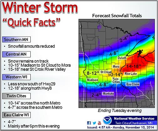
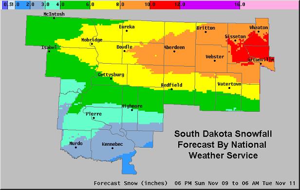
Snow totals of 6 to 12 and local totals to 15 inches will occur in portions Minnesota and northern and central Wisconsin while amounts in South Dakota vary from 4 to 10 inches. Some southern in southern North Dakota and western and northern Nebraska will get up to 5 inches of snow.
Travel across the Northern Plains was already being hindered Sunday and today promises to be a challenge, as well especially from South Dakota to Wisconsin where snow will fall into Tuesday.
Winter wheat in the northern Plains should become adequately protected against the cold weather by the snow that has already accumulated and that which is yet to come. Much of the crop was becoming dormant or semi-dormant before the storm hit there should not be any serious implications of winterkill – at least not in the northern Plains. With that said, there will be some areas in northeastern North Dakota and a few areas in Canada’s Prairies that may not have sufficient snow cover and temperatures will plummet near zero Fahrenheit over the next couple of mornings. World Weather, Inc. does not expect much, if any, winterkill in the northern Plains or Canada. However, there is some concern for wheat in the central Plains.
Some light snow will fall across Nebraska, northeastern Colorado and northwestern Kansas, but much of it is expected to be blown around leaving some crops exposed to temperatures dropping into the positive and negative single digits and teens. A strong high pressure center will settle over South Dakota and Nebraska Thursday morning forcing large amounts of cold air into the central Plains and Midwest. Some extreme lows may slip to the positive single digits and teens across some snow free areas in the central Plains and that will raise a little concern over wheat conditions. However, temperatures should stop short of the permanent damage threshold and a combination of somewhat warm soil conditions and a little snow cover in pockets should be sufficient to keep the crop viable.
Most of the soybeans in the northern Plains had been harvested as of last week, but corn and sunseed are still standing in many fields across the northern Plains. Both will be vulnerable to a heavy, wet, snow accumulation. Some lodging may occur and in the case of sunseed some of the remaining crop could be lost or suffer a serious decline in quality if conditions get bad enough. Sugarbeet harvesting was complete.
The situation will continue to be closely monitored.
[info]World Weather, Inc. forecasts and comments pertaining to present, past and future weather conditions included in this report constitute the corporation’s judgment as of the date of this report and are subject to change without notice. Comments regarding damage or the impact of weather on agricultural and energy as well as comments made regarding the impact of weather on the commodity and financial markets are the explicit opinions of World Weather, Inc. World Weather, Inc. cannot be held responsible for decisions made by users of the Corporation’s information in any business, trade or investment decision. ©2014 World Weather, Inc. Any unauthorized redistribution, duplication or disclosure is prohibited by law and will result in prosecution.[/info]