

Is Modoki El Nino Returning? Not Good For California
By Drew Lerner
Kansas City, February 22 (World Weather Inc.) – Changes in equatorial eastern Pacific Ocean temperatures are continuing, albeit gradually. These changes are necessary for El Nino to steadily weaken as predicted. Recent ocean data has revealed two very interesting features that will have influence on global weather in the next several weeks. First, El  Nino’s weakening trend has been slowed recently and it is expected to accelerate, but recent data suggests it may not be nearly as aggressive as once thought. The second feature is that ocean temperature anomalies are suddenly looking more like Modoki, El Nino, again, and that may not bode well for California or the Philippines.
The latest ocean data has revealed much information about El Nino and its progress. A low level westerly wind burst was noted last week in the central parts of the equatorial Pacific Ocean and that suggests some warming may occur in some of the eastern Pacific Ocean surface water in the next couple of weeks. In addition to that the latest Southern Oscillation data has dropped significantly recently also suggesting that El Nino may be getting a little temporary boost – or more likely it will not weaken with the same rate of significance that has been long suggested and advertised by various weather forecast entities.
World Weather, Inc. remains confident that no La Nina event will occur during the summer growing season 2016. There is still potential for La Nina later in the year, but only after the growing season has concluded. The latest computer forecast model data is a little confusing and leaves quite a bit of potential debate over the fate of El Nino.
 The U.S. National Ocean and Atmospheric Administration (NOAA) sea surface temperature model has been modifying its forecast weekly over the past month suggesting a slower rate of weakening in El Nino. Some of the more recent model data has actually left El Nino intact as a weak warm ENSO event through the summer. The jury is still out on that forecast, but confidence is still moderately strong that Neutral ENSO conditions will evolve later in the growing season.
The latest sea surface temperature data suggests significant cooling has occurred in the far eastern equatorial Pacific Ocean in recent weeks. In the meantime, weakening has been quite restricted between the International Dateline and 120 degrees west longitude. If the cooling continues to evolve in the far eastern parts of the equatorial Pacific and a notable warm pool of water remains near the central Pacific conditions will start evolving toward a Modoki El Nino event once again.
Modoki El Nino is mostly the same as other El Nino events except the warmest ocean temperature anomaly occurs further to the west near the central Pacific Ocean instead of including most of the eastern equatorial Pacific Ocean as noted in recent months. Modoki El Nino conditions were common in the winter of 2014-15 and were primarily responsible for drought in California and for drought in the Philippines.
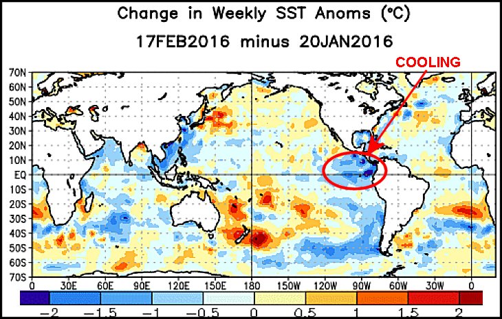 Recent precipitation in California has become much less frequent and less significant relative to that of January. It might be a short term aberration or the start of something more significant, but it is a little disturbing to see a trend toward Modoki El Nino again when California has done better with precipitation this winter season. The precipitation bias in California has not been as aggressive as needed to end a multi-year drought, but the snowpack in the Sierra Nevada is close to average for this time of year. The problem is that average snowpack is not good enough to end multiple years of serious drought.
The return of Modoki, could stymie the precipitation pattern just long enough to leave California drier than usual during the balance of its rain/snow season leaving the stage set with a serious drought for yet another year. The same kind of situation might occur in the Philippines, but this year’s Modoki event may be further to the east than last year’s event preventing the Philippines from becoming quite as dry as last year.
In the meantime, forecasters continued to closely monitor changes in subsurface ocean temperature anomalies across the equatorial Pacific Ocean because it has been learned over the years that changes in eastern equatorial Pacific surface ocean temperatures begin below the surface of the ocean. The chart below includes a series of five 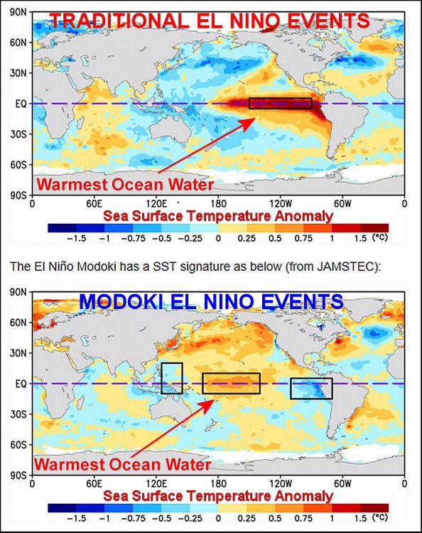 snapshots of subsurface ocean temperature anomalies varying from December 29 to February 17. The top of each box shown below is the surface of the ocean and the bottom is 300 meters below the surface. The heavy vertical line through the middle of each box is the International Dateline while the far right of each box would be where South America and Central America’s coasts would be located, if shown, and Australia would be close to the lower left of each box.
Notice the eastward shift of the colder water that is below the surface of the ocean in the western Pacific as time moves along. This cooler water will continue to undercut the warm water in the eastern Pacific Ocean and once the cooler water reaches far enough to the east it will begin lifting to the surface because of an upwelling current in the eastern most Pacific, indicated by the blue arrow. El Nino’s warm water at the surface will be eroded by both the eastward moving cooler than usual ocean water below the surface and eventually by the upwelling of that same water as time moves along.
The most important part of the imagery below is the fact that there is not enough cold water to counter the warm water and that is the primary reason why El Nino may stick around a little while longer than once suggested.
The recent wind burst, mentioned, above will help to induce a little more warming of surface ocean temperatures over the next couple of weeks while the cooler water moderates as it mixes in with the warm water. As a result, the odds are high that El Nino will take its time weakening and diminishing – at least for a while this spring and that may change a few agricultural weather forecasts from those who have been touting a hot, dry, summer.
The game is not over yet, but World Weather, Inc. is encouraged by the recent changes, or lack thereof, in regard to how this El Nino event will unfold. We still believe El Nino will weaken sufficiently during the spring and summer to allow other prevailing weather patterns to have greater control on world weather, including North America. For the United States that will translate into a warmer than usual bias in the southern Plains and Delta this summer while precipitation is restricted. Conditions in the northern U.S. Plains will be wet and mild during the summer along with the Canadian Prairies while Midwest weather will provide “some” timely rain.
One last comment needs to be made regarding the potential for El Nino to last longer than expected. Such conditions will raise the potential for western North America to move into spring with ongoing dryness and a potential for a longer lasting ridge of high pressure. That might result in less heat for the eastern United States this summer and a little more timely rainfall while western  Canada’s Prairies could be subjected to another spring of very warm and dry biased conditions.
Overseas, the impact of ongoing El Nino a little longer might leave a small amount of dryness in a part of eastern India during the monsoon of 2016, but there should still be improved rainfall in Southeast Asia relative to that of last year’s monsoon.
South America will likely experience status quo conditions through the balance of this summer’s growing season and the spring of 2016 will likely have favorable conditions.
There is still potential for La Nina, but most likely late this year and in 2017. Be aware that the situation in the Pacific Ocean still has plenty of potential for change in the next few weeks and month which warrants an ongoing close monitoring of the situation.
World Weather, Inc. forecasts and comments pertaining to present, past and future weather conditions included in this report constitute the corporation’s judgment as of the date of this report and are subject to change without notice. Comments regarding damage or the impact of weather on agricultural and energy as well as comments made regarding the impact of weather on the commodity and financial markets are the explicit opinions of World Weather, Inc. World Weather, Inc. cannot be held responsible for decisions made by users of the Corporation’s information in any business, trade or investment decision.
©2016 World Weather, Inc. Any unauthorized redistribution, duplication or disclosure is prohibited by law and will result in prosecution.