

U.S. March, April Weather Wettest Southeast
By Drew Lerner
Kansas City, February 29 (World Weather Inc.) – February weather in the United States was hard to complain about even though there was an early month blizzard in the central United States and a late month storm that produced significant amounts of moisture across the  Midwest and northeastern states for a little while. Most of the month was warmer and drier bias for many areas in the nation. March and April will progressively trend a little wetter, especially in the southern states and across a part of the central Plains. Temperatures will continue warm in the northern states, but will trend cooler than usual in the southeastern and southwestern corners of the nation. No area is expected more persistently wetter biased in the next two months than the southeastern U.S.
February 2-3 produced an impressive blizzard across the central Plains and upper Midwest with 8 to 18 inches of snowfall across portions of Colorado, Nebraska, Iowa and Wisconsin. That storm was followed by a weaker event Feb. 15-16 that produced widespread precipitation in the middle of the nation. A more significant storm system impacted the eastern 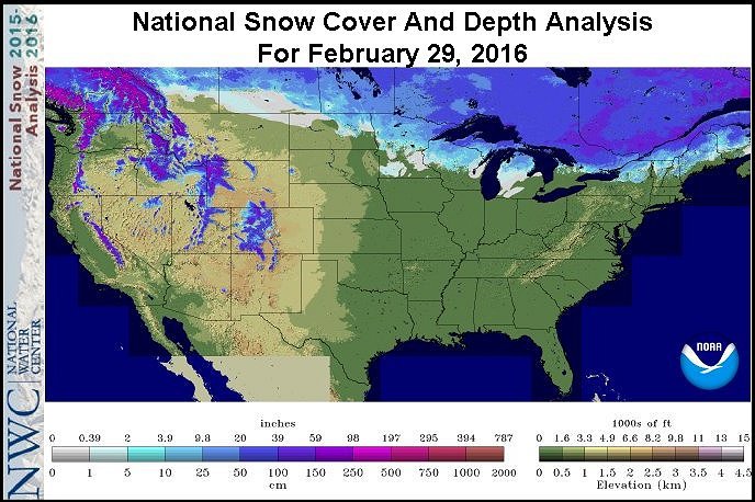 half of the nation Feb. 23-25 with 4 to 15 inches of snow occurring from the heart of the Midwest into the northeastern U.S. and southeastern Canada. These three storms were the highlighted events for February, although there were many other smaller disturbances.
Precipitation during the month was well above average from east-central and northeastern Colorado across Nebraska to portions of western and central Iowa and southwestern Minnesota. A portion of the northern Plains was also wetter biased with the only other wet region in the nation was from the eastern Midwest through New England and along the Carolina coast. The majority of other areas in the nation were drier biased in February. Precipitation was most anomalously low in the southwestern states from southern California through Arizona to parts of west Texas and in southern and eastern Kansas, Missouri, northern Oklahoma and northern Arkansas. South Texas was among the driest areas in the nation and that region along with the southwestern U.S. needs rain soon to support spring planting.
Soil moisture at the end of February was excessive in many areas from eastern Texas through the Delta to the southeastern states, eastern portions of the Midwest and from the Middle to the Northern Atlantic Coast States. These areas will all be vulnerable to flooding in March if there is not at least some break in the wet bias for a while.
 Snow cover had retreated to the northernmost parts of the U.S. at the end of February. Snow was on the ground in northern and western Michigan, northern Wisconsin and parts of Minnesota and North Dakota, but many areas were free of significant snow suggesting spring flooding may not be much of an issue. With that said, it is important to note that many areas in the lower and eastern Midwest, Delta and southeastern states are saturated with moisture. Snow melt may not be a big issue for spring flooding – at least not based on today’s snow cover, but large precipitation events in March could still capitalize on the soggy field conditions and induce flooding on its own.
March and April weather will see some typical weather patterns associated with the mature phase of El Nino and the likelihood of weakening El Nino through spring. The mostly highly correlated anomaly will be wet conditions in the southeastern United States. Statistics suggest there have been no significantly strong El Nino events in the past that have not produce abundant precipitation in the southeastern states in March and April. The wet bias is expected to result in some delay to farming activity periodically.
Some early season fieldwork is already under way in the lower Delta and in a few areas in South Texas and the 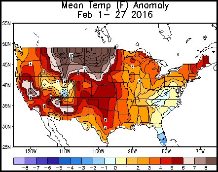 southeastern states. The wetter tendencies expected during March and April will eventually lead to delays in early season farming activity and to restrict early season crop growth and development.
The wet biased southeastern states will also experience a cooler than usual temperature regime and that will contribute to the slow crop development. Cool weather is also expected in parts of California and the southwestern desert region over the next two months.
In contrast, the cooler conditions in the southern states, most of the northern states will continue to experience warmer than usual weather. With that said, there will be some periodic bouts of cold air that will influence eastern Canada’s Prairies and the upper Midwest and parts of both the Great Lakes region and the northeastern states. The cold bouts will not be as persistent in March as they will be in April, but both months will still experience some impressive cold bouts of air  infrequently.
Watch the Arctic Oscillation very closely over the next few weeks. World Weather, Inc. believes we are headed into a transitionary period in which the dominating positive phase of Arctic Oscillation (AO) will be giving way to the negative phase. Once the negative AO settles in the bouts of cold in the Midwest and eastern states will become more significant. The El Nino phenomenon will likely keep warm air present in the northern Plains and western parts of North America for a while in March, but as time moves along and the negative AO begins there will likely be a tendency for cooler biased conditions to erupt over eastern North America. Once this change occurs the outlook for April is likely to be revised toward a cooler tendency for the eastern U.S.
The driest biased areas in the U.S. and Canada during March and April will be in the west. Mostly the Pacific Northwest, British Colombia, Alberta and western and southern Saskatchewan will be driest relative to normal. The drier tendencies in March will not be very important because of cooler biased conditions that will still keep crop development potentials low and soil moisture will be conserved through slow evaporation rates. However, the same pattern in April will be accompanied by faster drying and some early season crop development and planting. The drier and warmer bias in April will be more of a concern because of the new crops going into the ground and moisture deficits still lingering from last year.
West Texas and the southern Plains, in general, will be a closely monitored region over the next two months. The region is expected to be drier and warmer than usual this summer putting much pressure on spring weather to be as wet as possible so that soil moisture and water reserves are bolstered as much as possible before the big drying trend occurs during the summer. The southern Plains will receive near to above average precipitation over the next few weeks, although confidence is not very high and there is potential that some of the region will not get as much rain as others.
World Weather, Inc. forecasts and comments pertaining to present, past and future weather conditions included in this report constitute the corporation’s judgment as of the date of this report and are subject to change without notice. Comments regarding damage or the impact of weather on agricultural and energy as well as comments made regarding the impact of weather on the commodity and financial markets are the explicit opinions of World Weather, Inc. World Weather, Inc. cannot be held responsible for decisions made by users of the Corporation’s information in any business, trade or investment decision.
©2016 World Weather, Inc. Any unauthorized redistribution, duplication or disclosure is prohibited by law and will result in prosecution.