

U.S. Midwest Rain To Confine Driest Areas To Southwest
By Andrew Owen and Drew Lerner
Kansas City, June 21 (World Weather Inc.) – Rain expected tonight and Wednesday from northern and eastern Iowa to Ohio and Kentucky will help confine the driest areas in the U.S. Midwest to the southwest, as expected for the month of June. Weather patterns in the past few weeks have occurred about as expected and the impact has left much of the nation’s corn and soybean crop in good shape. The exception is in southwestern portions of the production region where enough drying has occurred recently to begin stressing crops, although many crops have not gone beyond the point of no return and a significant rain in the next couple of weeks could help the stressed crop greatly. Very little potential yield loss is suspected.
Even though the comments above tend to suggest that all is well, it is important to note that rainfall in recent weeks has been below average. The 30-day, 60-day and 90-day periods have all been lighter than usual on rainfall from southern Iowa and Missouri to Ohio and southern Michigan and that has many folks concerned. Any significant period of hot, dry, weather that evolves in July could quickly take this mostly fine looking crop and stress it seriously in a relatively short period of time. That kind of comment is not unusual for late summer, but it is a concern for it only being June 21. There are many weeks left to the growing season and the pressure will be on for a while to get more timely rainfall like that which has occurred in June to maintain the best possible production potential.

Most of the forecasts, World Weather, Inc.’s in particular, suggest that July will be the harshest month of the growing season and if there is going to be a problem with dominating heat and dryness is it more likely to occur in July than later in the season. Actually, the first half to two-thirds of the month will be closely monitored because of the potential for ongoing restricted rainfall and warmer than usual temperatures. A little later in July and in August the southwest monsoon is expected to kick in and bring moisture through the Rocky Mountains and into the northern Plains before sending showers and thunderstorms over the top and front side of a ridge of high pressure expected to be anchored in the middle of the nation at that time. Rolling thunderstorm clusters off the peak of a ridge of high pressure in the heart of the nation during the summer can bring locally heavy rainfall to areas downstream and in this case we may see such conditions evolve in the northern and eastern Corn and Soybean Belt over time. That moisture will provide some renewed relief from net drying conditions while the southwestern Corn Belt may continue to deal with a more persistent problem with heat and dryness.
In the meantime, rainfall varied across the Corn and Soybean Belt during the past week. Areas from Nebraska, the northern two-thirds of Iowa, and the northern Plains through Wisconsin, northern and eastern Illinois, Indiana, and western Michigan received 0.50 to 3.00 inches of rain for the seven day period ending this morning. Local amounts of 5.00 inches or more were noted in portions of eastern Nebraska, Minnesota, northern Missouri, eastern North Dakota, southern Wisconsin, and northern Illinois. Ohio and eastern Michigan received 0.25 to 1.50 inches of rain most often. Northern Missouri, southern Iowa, and western fringes of Illinois received little to no precipitation. Temperatures were often warm with daytime highs frequently peaking into the 80s and 90s Fahrenheit.

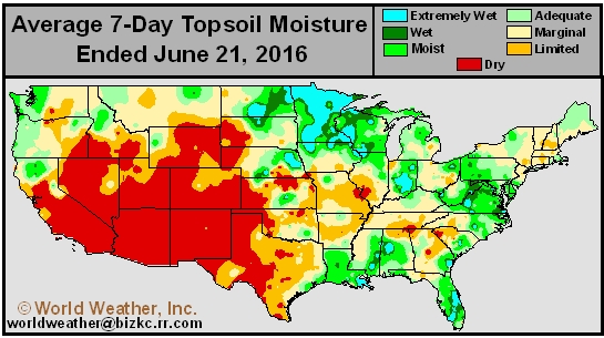
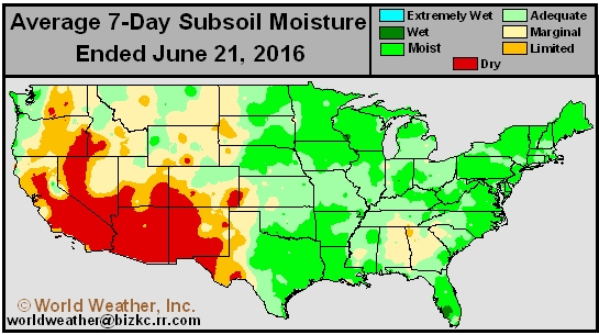
The lack of rain and warm weather in some southwestern Corn Belt locations promoted aggressive drying in the topsoil for central Missouri, southern Iowa, and neighboring areas in Illinois. A drying tendency was also noted in other portions of the eastern Corn Belt. Despite the drier biased conditions in the topsoil, most locations still have adequate subsoil moisture. The remaining portions of the Midwest have generally favorable topsoil moisture.
Corn and soybean growth conditions were mostly favorable across the Midwest in recent weeks. Precipitation since the beginning of June has been near to below average in a large swath of the main production areas. The drying tendency was welcome in many areas after cool weather earlier in the spring kept moisture abundances around longer than desired leaving crop development a little sub-par for this time of year. The drier tendency was ideal for late season planting and routine spraying and fertilizer application, but timely rain is more important now and – so far that is exactly what has been occurring.
Prior to last night northern Missouri was among the driest areas in the Midwest, but a cluster of thunderstorms brought significant relief to a part of that region. More rain was needed. The latest data shows east-central and central Missouri, southwestern Illinois and portions of the northern Delta, eastern Kansas and far southeastern Nebraska as driest. Rain is expected tonight and Wednesday to help ease some of the dryness from northern and eastern Iowa to Ohio, but it may miss some of the driest areas in the southwestern Corn Belt.
Two disturbances will promote scattered showers and thunderstorms in the Midwest this week. A low pressure center will advance across the heart of the Midwest tonight into Thursday that will produce timely rain in most areas outside of Missouri, Nebraska, and immediate neighboring areas. A second low pressure center and associated frontal passage will then sweep across the region Saturday into Monday, producing rain in much of the Corn Belt. Several areas will also receive light rain today. Moisture totals by this time next week will range from 0.50 to 2.00 inches with local totals of 2.00 to 3.00 inches from eastern Iowa to Ohio. Some areas in the drier regions of the southwestern Corn Belt will not likely get 0.50 inch and net drying will continue. Portions of South Dakota will also be left in a significant drying trend over the coming week.
Temperatures will trend near to above average across the Midwest over the coming week. Daytime highs in the north will be in the 70s and 80s while readings in the south will be in the 80s and lower 90s. Several areas west of the Missouri River and especially in the southwestern Corn Belt will reach into the middle and upper 90s to near 100 degrees just shortly before each of the two rain events. Crop stress will be greatest in parts of Kansas, central Missouri, southeastern Nebraska and southwestern Iowa, but some will evolve in South Dakota, as well. The stress advertised may be eased by the predicted scattering of showers and thunderstorms short term bouts of cooling that will come with the rainfall.
Hard Red Winter Wheat
Winter wheat maturation and harvest progress is near to behind normal in Texas, Oklahoma, and Kansas due to wet weather earlier this spring. Rainfall in the most recent week was high enough to again impact maturation and harvest rates with rain totals ranging from 0.50 to 3.00 inches with a few wetter pockets in Kansas and drier pockets in extreme southwestern fringes of the production region. Despite the rainfall, temperatures were warm enough to promote aggressive drying. Maturation and harvesting conditions were favorable between rain events.
A weak high pressure ridge will help promote drier than normal conditions across the central and southern Plains through the end of the work week. The brief periods of light rain that occur will not be enough to counter evaporation. A frontal passage will then promote scattered showers and isolated thunderstorms over the weekend and next Monday. Moisture totals will range from 0.30 to 1.25 inches with locally greater amounts. Much of the rain will again be lost to evaporation. Daytime highs will often peak into the 80s and 90s with pockets in the high Plains warming over 100 degrees through Saturday. The warm weather will promote aggressive drying between rain events. Maturation and harvesting will advance swiftly through Friday. Minor harvest and fieldwork delays will be possible over the weekend and next Monday due to rainfall, though no major delays are expected.
Delta and Southeast
Erratic rainfall was reported in the Delta during the past week with Louisiana and neighboring areas receiving 1.00 to 5.00 inches of rain. Central and northern sections of the Delta were drier compared to areas further south with moisture totals ranging from a trace to 0.50 inch with locally greater amounts. The lack of rain and periods of warm weather firmed up the topsoil in northern and central sections of the Delta. The ground is excessively dry yet and crop growth conditions in recent weeks have been mostly favorable. As long as timely rain falls through the end of June, development conditions will remain favorable in the Delta.
Other than a few stray showers, the Delta will trend dry this week. The ground will continue to firm with moisture areas trending dry in the topsoil by the beginning of next week. Irrigation will be the primary source for moisture. There is potential for a higher frequency of rainfall during the second week of the outlook that could help slow or reverse the drying trend. However, stressful conditions will be possible at times in northern and central sections of the Delta.
Rainfall was also erratically distributed across the southeastern states during the past week. Alabama received 1.00 to 6.00 inches of rain while southern Georgia, southern South Carolina, and portions of NS received 0.05 to 2.00 inches of rain with locally greater amounts. Northern Georgia and the remaining portions of the Carolinas received little or no rain. Several areas in Georgia and the Carolinas have short to very short soil moisture and would benefit from more rain in the near future.
High pressure will limit rainfall in the southeast through Friday. Light shower activity will evolve this weekend that will continue into the beginning of next week, though resulting rainfall will often be too light to counter evaporation. Dryness concerns will continue, most notably in Georgia. Stressful conditions will continue for the drier biased areas.
World Weather, Inc. forecasts and comments pertaining to present, past and future weather conditions included in this report constitute the corporation’s judgment as of the date of this report and are subject to change without notice. Comments regarding damage or the impact of weather on agricultural and energy as well as comments made regarding the impact of weather on the commodity and financial markets are the explicit opinions of World Weather, Inc. World Weather, Inc. can not be held responsible for decisions made by users of the Corporation’s information in any business, trade or investment decision.
©2016 World Weather, Inc. Any unauthorized redistribution, duplication or disclosure is prohibited by law and will result in prosecution.