

U.S. Late August Weather Unlikely To Veer From Trend
By Andrew Owen and Drew Lerner
Kansas City, August 17 (World Weather Inc.) – Pockets of dryness have occurred this summer, but there have been no large regions of critically dry weather – at least not in key Midwestern crop areas. The trend is unlikely to veer in the balance of August virtually assuring good soybean and corn yields. Dryness that had been a big worry last week in Michigan, Ohio and northeastern Indiana was quickly put down by generalized rainfall during the weekend and early this week. There are still some lingering areas of greater rainfall need, but the areas still bothered by dryness have been greatly reduced. The balance of August is expected to reinforce this situation leaving most of the Midwest in a status quo pattern promising further support for high yielding crops.

Areas from southeastern Missouri through southern, central, and eastern Illinois into much of Indiana, Ohio, and Michigan received significant rain during the past week. Moisture totals for the seven-day period ending this morning ranged from 1.50 to 5.00 inches with several areas in southeastern Missouri, southern Illinois, southern Indiana, northern Indiana, and southern Michigan receiving 5.00 to over 10.00 inches of rain. Flooding was reported in the wetter biased locations, which may have damaged some of the crop. Other sections of the Corn and Soybean Belt received 0.50 to 3.00 inches of rain with local amounts of 5.00 inches or more in Minnesota and southeastern North Dakota.

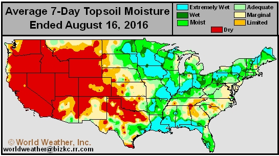
Soil moisture is rated adequate or excessive in much of the Midwest. The rain was welcome in the drier areas of the eastern Corn Belt while many areas from Missouri and Illinois through Minnesota did not have a pressing need for additional precipitation. Recent rainfall was high enough in much of Ohio, Indiana, and Michigan to restore soil moisture to levels that will support summer crops without much need for follow up rain. However, dryness does still linger in northeastern Indiana and northwestern Ohio where some need for additional rain remains. There is also a new area of drying in the southwestern Corn Belt that may require some attention soon.
Portions of the Midwest may benefit from some drier weather in the next few weeks to help promote corn maturation, but soybeans will still require a little rain periodically along with sorghum to assure a good finish to the growing season.
Recent heavier rainfall in the Gulf of Mexico coastal region, the western and northern Delta and lower and eastern Midwest has left the ground too wet to be worked and drier weather will be needed soon. The upper most Midwest also received significant rain recently and might benefit from some short term drier bias.
Heavy rain in southern Louisiana promoted severe flooding in southern fringes of the production region in recent days. Rain totals during the 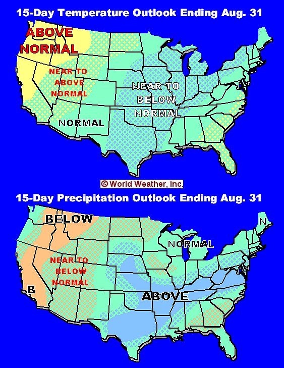 past week ranged from 8.00 to more than 26.00 inches resulting in some of the worst flooding southern Louisiana has experienced that was not associated with a hurricane or tropical cyclone.
Weather conditions in the coming two weeks will be a little cooler biased in the heart of the Midwest. A combination of additional rainfall, periodic cloudiness and two distinctive cool air masses dropping into the region from Canada will assure that soil moisture stays adequate to abundant into the final days of this month. The environment assures favorable soil moisture for crop development into early September without any reason to be concerned over significant dryness. Production potentials will remain very high in the heart of the Midwest and favorable in the far west and extreme eastern parts of the region.
Harvest delays are likely in the Delta because of too much moisture in the next couple of weeks while the southeastern states experience a good mix of rainfall and sunshine. West Texas and most other areas in the southern Plains will be impacted by abundant rainfall in the coming week. Sufficient rain will fall in the southern Plains in this coming week to assure the month of August is wetter biased in all areas except possibly the far south and parts of the Texas Panhandle. Much of the lower Midwest will be a little wetter biased in the next two weeks while normal precipitation occurs in the north and there will be some tendency for below average rainfall in parts of Iowa, northeastern Missouri and the far northern Plains.
World Weather, Inc. forecasts and comments pertaining to present, past and future weather conditions included in this report constitute the corporation’s judgment as of the date of this report and are subject to change without notice. Comments regarding damage or the impact of weather on agricultural and energy as well as comments made regarding the impact of weather on the commodity and financial markets are the explicit opinions of World Weather, Inc. World Weather, Inc. can not be held responsible for decisions made by users of the Corporation’s information in any business, trade or investment decision.
©2016 World Weather, Inc. Any unauthorized redistribution, duplication or disclosure is prohibited by law and will result in prosecution.