

Typhoon Meranti To Impact South China; Malakas Japan
By Andrew Owen
Kansas City, September 14 (World Weather Inc.) – After producing over 20.00 inches of rain in portions of Taiwan’s mountainous locations, Typhoon Meranti will now track into Fujian, China later today. Meranti will produce heavy rain for portions of Fujian, Zhejiang, southern Jiangsu, and neighboring areas in eastern China through Friday. Flooding will be  possible and could damage some of the rice and sugarcane, although the heaviest rain will fall outside the main production areas. The disturbance will then be absorbed by Typhoon Malakas as it drifts over southern portions of the East China Sea this weekend. Typhoon Malakas will also produce heavy rain in portions of southern South Korea and Kyushu, Japan Friday evening and Saturday morning before drifting northeasterly into Honshu through Sunday evening. Some damage to rice will be possible due to flooding.
At 1500 GMT, Typhoon Meranti was located near 23.9 north, 118.4 east, or 176 miles west-southwest of Taipei, Taiwan. Movement was northwesterly at 14 mph during the previous six hours. Maximum sustained surface wind speeds were at 144 mph, gusting up to 173 mph. Typhoon force wind speeds (greater than 73 mph) were occurring upwards of 69 miles away from the center of the system. Tropical storm force wind speeds (39 to 73 mph) were occurring upwards of 230 miles away from the center of the disturbance.
Typhoon Meranti will slowly drift into Fujian, China today and will shift northerly into Zhejiang and neighboring areas Thursday. Significant weakening will occur once the disturbance tracks over mainland China. Meranti will become a tropical storm by Thursday morning and will weaken further into a depression by Friday morning. Remnants of Typhoon Meranti will then be absorbed throughout the day Friday as Typhoon Malakas tracks into the East China Sea over Japan’s Ryukyu Islands.
Rainfall from Typhoon Meranti will be greatest along the coasts of Fujian and Zhejiang with moisture totals ranging from 5.00 to 10.00 inches with locally greater amounts possible. Sustained wind speeds will also be well in excess of 100 mph with gusts approaching 150 mph when Meranti makes landfall. Crop and structural damage will be possible in many areas in this common border region, although the main rice and sugarcane production areas are further inland in Fujian and Zhejiang.
Areas further inland in Fujian and Zhejiang, along with neighboring areas in eastern Guangdong, Jiangxi, Anhui, and southern Jiangsu, will receive 2.00 to 7.00 inches of rain with locally greater amounts from Typhoon Meranti. Flooding will be possible and could damage some of the rice, sugarcane, and other crops produced in the region. However, damage is expected to be minimal in most locations. No major production cuts are expected for most locations.
At 1500 GMT, Typhoon Malakas was located near 16.5 north, 130.7 east, or 733 miles south-southeast of Kaden Air Base, Japan. Movement was west-northwesterly at 14 mph during the previous six hours. Maximum sustained surface wind speeds were at 81 mph, gusting up to 98 mph. 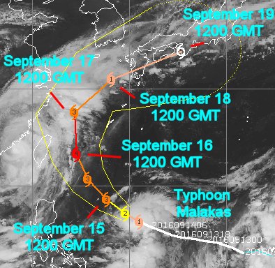 Typhoon force wind speeds were occurring outwards of 29 miles away from the center of the disturbance. Tropical storm force wind speeds were occurring up to 121 miles away from the center of Malakas.
Typhoon Malakas will slowly strengthen when advancing northwesterly across the Pacific Ocean today and Thursday. The disturbance will shift northerly into the East China Sea Friday while absorbing moisture from remnants of Typhoon Meranti. Malakas will then accelerate to the northeast over Kyushu, Shikoku, and Honshu Japan over the weekend before racing back into the Pacific Ocean by Monday morning.
Typhoon Malakas will track through the southern Ryukyu Islands east of Taiwan Friday before shifting into southern portions of the East China Sea. A few locations along the east coast of Taiwan could receive 1.00 to 3.00 inches of rain, although the disturbance is not expected to have a major impact on much of the country.
Outer rain bands from Malakas will track into portions of southern South Korea and Kyushu Friday evening and for parts of the day Saturday as the disturbance continues to drift further north over the East China Sea. Malakas will then drift east-northeasterly over Kyushu, Shikoku, and southern Honshu Sunday and Monday. Rain amounts will range from 1.50 to 5.00 inches with locally greater amounts possible in southern sections of Kyushu. There is a chance Malakas will shift further northeast over northern Honshu, which could promote significant rain for the area. A close monitoring of the situation is warranted in the coming days.
World Weather, Inc. forecasts and comments pertaining to present, past and future weather conditions included in this report constitute the corporation’s judgment as of the date of this report and are subject to change without notice. Comments regarding damage or the impact of weather on agricultural and energy as well as comments made regarding the impact of weather on the commodity and financial markets are the explicit opinions of World Weather, Inc. World Weather, Inc. can not be held responsible for decisions made by users of the Corporation’s information in any business, trade or investment decision.
©2016 World Weather, Inc. Any unauthorized redistribution, duplication or disclosure is prohibited by law and will result in prosecution.