

South America Spring Outlook Favorable Without La Nina
By Drew Lerner
Kansas City, September 9 (World Weather Inc.) – The South America spring season is just around the corner and the outlook for Argentina, Brazil, Paraguay and Uruguay is mostly favorable, especially now that the odds are disfavoring much influence from La Nina. Argentina will have  some rough weather over the next 30-45 days. Otherwise, the outlook for most grain oilseed, sugarcane, rice, and cotton production in the region is looking quite favorable.
Earlier this year many forecasters were predicting a significant La Nina event and that its presence would seriously impact South America production of many crops this year. Changes in ENSO conditions in recent weeks have suggested that La Nina-like conditions may be as good as it gets for influence on South America weather. Such an environment is really not much different from neutral ENSO conditions, but there may be a slight cooler bias in ocean surface temperatures across the eastern equatorial Pacific Ocean and that might give the impression of La Nina periodically even though technically La Nina will not exist.
The lack of influence from ENSO on world weather during the next few months opens the door of opportunity for other weather 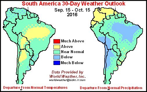 patterns that would often be operating in the background of La Nina to have more influence on weather in South America and the remainder of the world. For Brazil, Argentina, Uruguay and Paraguay that influence is expected to be mostly favorable for production in 2016-17. Timely rainfall and seasonable temperatures will dominate much of the South American crop production region.
The toughest month of weather for Argentina this spring (September through November) will be Sep 15-Oct. 14. A dry biased pattern has already evolved across the western and southern Argentina and it is expected to continue in the September 15-October 14 period. Rainfall in August was minimal from western and central Santa Fe and Cordoba southward to northern and eastern La Pampa and from there across much of Buenos Aires. The first eight days in September were nearly as dry.
 The situation in Argentina is not surprising and it will continue for another 30 to 45 days with some altercations. Much concern about wheat conditions in western and northern production areas in Argentina is expected to evolve and the early planting of corn, sunseed and other crops will be delayed until greater rain evolves. Most of the remaining weeks in September will not offer any tremendous changes to the present weather pattern and that will likely leave rainfall well below average in many important crop areas.
A little more active jet stream is expected to evolve in Argentina during early October and it should not be too much later than mid- to late October that rain will begin falling more routinely across the nation. The precipitation may be erratic initially, but by the latter part of October weather conditions should be much more normal.
 For September 15-Oct 14, rainfall will be below average in most of Chile, and west-central and northwestern Argentina. Portions of Bolivia and southern Peru will also be a part of this pattern. The first 30 days of spring will also be drier than usual in northern portions of Brazil while rainfall may be greater than usual from Uruguay into Parana and a part of southern Mato Grosso do Sul. Unlike in recent past years, the wetter bias in southern Brazil is not expected to result in a serious decline in wheat conditions and as the weather pattern evolves into a more normal pattern in October the rainy conditions in southern Brazil will be quick to abate.
The temperature bias over the 30-day period ending October 14 will be warmer than usual in northern Argentina, Bolivia and northern portions of Brazil. Colombia, Venezuela and Ecuador are expected to see wetter biased conditions and temperatures may be a little cooler than usual because of the wet bias.
 Conditions in October and November are expected to change in South America. The lack of rain in Argentina and some areas in northern Brazil should abate somewhat. The drier bias in northwestern and west central Argentina should become a near to above average precipitation bias during the October and November. Some of the warmer biases in temperatures expected September 15 to October 14 will have a lingering influence on the 90-day forecast, but most of the temperatures in from mid-October to late November are expected to be seasonable.
Rainfall over the entire spring season will be a little greater than usual from southern Minas Gerais, Sao Paulo and northern Parana to Peru, Bolivia, Paraguay and far northern Argentina. The wetter bias will support aggressive crop development. In contrast, far southern Argentina will experience a little drier bias during the mid-October through mid-December period. Another drier biased area will be from interior portions of Columbia and Venezuela to Tocantins and western Bahia. There is a fair chance that greater rainfall will evolve in northern Brazil during the summer favoring better grain, oilseed and cotton crop performance after an extended period of dry weather.
World Weather, Inc. forecasts and comments pertaining to present, past and future weather conditions included in this report constitute the corporation’s judgment as of the date of this report and are subject to change without notice. Comments regarding damage or the impact of weather on agricultural and energy as well as comments made regarding the impact of weather on the commodity and financial markets are the explicit opinions of World Weather, Inc. World Weather, Inc. cannot be held responsible for decisions made by users of the Corporation’s information in any business, trade or investment decision.
©2016 World Weather, Inc. Any unauthorized redistribution, duplication or disclosure is prohibited by law and will result in prosecution.