

Brazil Early October Rain Beneficial, Dry Pockets Remain
By Drew Lerner
Kansas City, October 9 (World Weather Inc.) – Scattered showers and thunderstorms in Brazil during the first nine days of October have brought in some beneficial moisture to many crop areas, but not all. Typically, early October rainfall is erratic and even though there are pockets of  dryness lingering the pattern should be interpreted as mostly normal for this time of year. Subsoil moisture is still quite low and the pockets of dryness out there will make some producers and traders a little nervous for a while, but seasonal rains usually occur in Late October and November and there is little reason to expect a failing in that rain. In the meantime, many areas will trend drier.
The most unusual part of the early October rainfall this year has been that which occurred from eastern and northern Mato Grosso through Goias to Minas Gerais and Bahia. Significant rain in these areas usually does not come so significantly so early, but all of it was welcome and good for improving early season planting of cotton, corn, soybeans and a few other crops.
Coffee production areas have experienced an erratic rainfall pattern, with flowering reported earlier in September from Parana  into southwestern Sao Paulo and then more recently in many production areas of western and interior southern Minas Gerais. Some significant rain in northeastern Minas Gerais and parts of Bahia also occurred recently. Each of these areas may have experienced some flowering, but it has not occurred at the same time. There are also many areas in southern Minas Gerais, northeastern Sao Paulo, Zona de Mata (areas near the common borders of Espirito Santo, Minas Gerais, and Rio de Janeiro) and south-central Bahia that have not received enough rain for flowering. None of this is a big concern, but the 2017 harvest season will likely be stretched out because flowering has been staggered across the production region with some areas still waiting on significant rain.
Most of the grain and oilseed production areas have reported a favorable rainfall pattern so far this month. However, it has been erratic enough that not all farmers have been able to begin fieldwork which is not unusual for this time of year. It is frustrating  for those who want to get early season crops planted so that they can be harvested in time to plant second season crops without running into moisture shortages when the rainy season winds down in late March and April.
Rainfall has been unusually significant early this year in Bahia, parts of Minas Gerais and Goias, but as early as significant rain has been in those areas parts of Rio Grande do Sul, Parana and Sao Paulo have reported below average Rainfall. Some of the region has been quite dry and a part of the dry region extends northward into parts of southern Mato Grosso. The trend noted in early October rainfall is very similar to that which occurs during La Nina events. The recent rise in the Southern Oscillation Index (SOI) has reflected La Nina like conditions that have evolved which is why the precipitation in Brazil has been distributed in the manner described above.
 The weekend SOI began weakening and the trend is expected to continue for a while and that may reduce the La Nina like conditions for a little while. The forecast for this week is already offering some improved rainfall for southern Brazil. Rio Grande do Sul, Santa Catarina, Parana and Paraguay, along with parts of Uruguay and northeastern Argentina, will receive significant rain soon. Computer forecast models have been suggesting rainfall will move through far southern Brazil in waves during the coming week with Rio Grande do Sul expecting some of the greatest amounts – possibly ranging from 1.00 to 2.00 inches in the north and 2.00 to 4.00 inches in the south. Rainfall of 1.00 to 2.00 inches will also occur in Santa Catarina, southern Paraguay and southern Parana later this week as well. Most of the rain will begin Wednesday and continue Friday with a second round of it expected Saturday through much of next week. Excessive rain may fall in portions of Rio Grande do Sul.
Heavy rain in Rio Grande do Sul will likely saturate the soil and possibly lead to some flooding. A similar concern is possible for Santa Catarina, far southern Paraguay and southern Parana, although rainfall in these areas will not be as intensive or as persistent allowing each rain event enough time to soak into the ground.
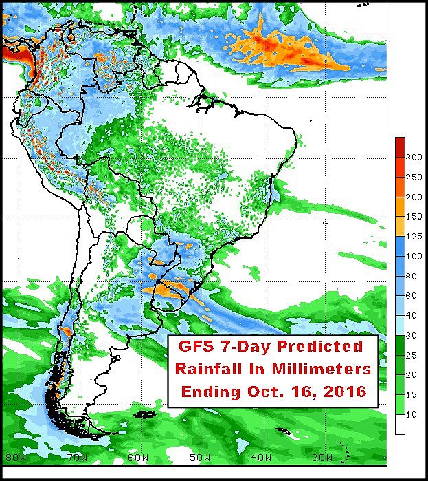 The forecast is not all good for Brazil crop areas. Showers are advertised erratically across many areas in the nation over the next two weeks, but resulting rainfall is not going to be very great from Mato Grosso do Sul into Sao Paulo and possibly far northern Parana. Rainfall is also expected to be restricted in Bahia, northern Minas Gerais, parts of Goias and Tocantins. Warming temperatures in many center west, center south and northeastern crop areas during the next ten days will keep evaporation rates strong and that will make it difficult for a net increase in soil moisture to take place. The situation will be closely monitored.
World Weather, Inc. will be watching Sap Paulo rainfall and areas northwest into southern Mato Grosso most closely since this is a region that producers like to get planted very quickly in the spring. Planting is expected to go quickly except in the driest areas, but emergence and establishment will be slow until greater rainfall evolves.
It is still very important to keep in mind that monsoonal rainfall quite often evolves in late October and November and despite farmers’ desires to get planting going now they may have to wait for the next wave of rain until later this month. Most likely many will plant in the soil as it is today and hope for the best. World Weather, Inc. sees very little reason to expect any prolonged delays in rainfall this season. Some of the rain may be lighter than usual in the interior south, but enough 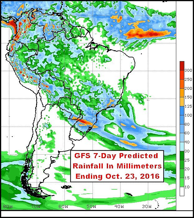 will fall to support planting – in time.
Temperatures over the coming week are expected to be near to above average for much of Brazil. There may be some slight cooler biased conditions in the northeast and there may be some near average readings in the far south. However, much of center west into center south crop areas – the region with some dryness pockets in the topsoil – will be warm with daily highs in the 80s and 90s Fahrenheit. Extreme highs over 100 degrees will occur occasionally and it should not take long for dryness to return in the topsoil for many areas.
Most of the showers and thunderstorms this week will be erratic and mostly too light to bolster soil moisture in a major way across these important crop areas. That will result in rising concern over returning dryness as time moves along for grain and oilseed producers and traders. For the coffee market, there should not be any immediate impact, but for those coffee trees that have already flowered this year there is going to be a steadily rising bit of concern for follow up rain later this month to support pollination and to prevent any flower aborting. Production could suffer if the early flowered crops do not get sufficient rain and some of the blossoms are lost. Flowering will occur later in the rainy season, but sometimes the initial blooms lost are not made up in future flowering sessions.
World Weather, Inc. is still confident that seasonal rains will come in time to fix the worry for many producers and traders, but the next couple of weeks might be a little more volatile in the market place until greater rain falls.
Second week rainfall predicted by the GFS model does increase rainfall somewhat, but it is still not advertised to be a soaking. The concern about dryness will likely linger into the last days of the month when rain should begin increasing more significantly.
World Weather, Inc. forecasts and comments pertaining to present, past and future weather conditions included in this report constitute the corporation’s judgment as of the date of this report and are subject to change without notice. Comments regarding damage or the impact of weather on agricultural and energy as well as comments made regarding the impact of weather on the commodity and financial markets are the explicit opinions of World Weather, Inc. World Weather, Inc. cannot be held responsible for decisions made by users of the Corporation’s information in any business, trade or investment decision.
©2016 World Weather, Inc. Any unauthorized redistribution, duplication or disclosure is prohibited by law and will result in prosecution.