

Southeast U.S. 30-Day Weather Impressive, Problematic
By Andrew Owen and Drew Lerner
 Kansas City, October 10 (World Weather Inc.) – Southeastern portions of the United States have been a land of contrasts over the past 30 days. Exceptional rainfall and flooding have impacted the Carolinas, Virginia and the Delmarva Peninsula while dry and very warm weather occurred from Arkansas and northern Louisiana to central and northern Alabama. Rainfall from Hurricane Matthew, Tropical Storm Julia and a strange pocketed area of disturbed subtropical weather Sept. 27-29 produced rainfall of 12.00 to more than 26.00 inches while just a few hundred miles to the west there was no rain. The contrast in weather has been impressive, but also problematic, especially when Hurricane Matthew pushed through the Carolinas, eastern Georgia, northern Florida and southeastern Virginia this past weekend. Now that the hurricane is gone the farming community is looking for more “normal” weather.
 Hurricane Matthew recently produced heavy rain along much of the lower U.S. Atlantic coast. The disturbance promoted flooding rainfall and very strong wind speeds that damaged crops and structures from northeastern Florida through eastern Virginia. Several areas in the region from eastern North Carolina to the Delmarva Peninsula reported heavy rain September 19-22 and again September 27-29. The wetter biased environment for eastern South Carolina, North Carolina, and southern and eastern Virginia during the past month is in sharp contrast from the drier than normal conditions reported in the Delta and other sections of the southeastern states. The abundant moisture near the Atlantic coast and lack of moisture further inland have resulted in a number of issues – both good and bad – for crops in the two regions.
The dry weather in the Delta and interior southeastern states was ideal for speeding along summer crop maturation. However, daily high temperatures in the 80s and 90s Fahrenheit kept evaporation  rates very high and that stressed some late season crops into reducing crop quality and yield somewhat. The biggest concern in the Delta and interior southeastern states now is more about winter crop planting than summer crop harvesting and significant rain will have to fall soon.
Some of the dryness in Alabama and western Georgia goes much further back into the summer season. The lack of precipitation in unirrigated fields hurt cotton, soybean and peanut production. The situation might have been many times worse had there not been some short term improvement in rainfall across the region during the middle of summer.
In contrast to the dryness from Arkansas and northern Louisiana to western Georgia, the excessive rainfall in the Carolinas and Virginia likely damaged some cotton, peanuts and soybeans. A few other crops in the region were negatively impacted, as well, but 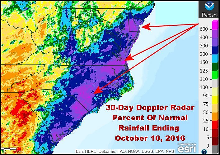 the situation has not been fully assessed. Damage estimates from Hurricane Matthew may go up as time moves along. Most of the storm’s rainfall in the eastern and central Carolinas and Virginia was no less than 6.00 inches and many areas received 10.00 to 17.00 inches. So much rain over a very large region resulted in record flooding. Most of the region’s rivers and streams drain into the Atlantic Ocean unlike the Midwest where heavy rain events drain into the Ohio, Missouri or Mississippi River Basins and then causes new flooding. At least in this case, flooding will mostly be confined to the coastal states and the flood water should be quick to drain from the region.
Quick draining flood water might not prolong the pain of flooding, but it certainly will do nothing to minimize the damage. The situation will be closely monitored and assessed over the next few weeks.
Tropical cyclones often make the southeastern United States exceptionally wet. The three weather systems noted above in the past 30 days produced rainfall that was two to more than four times normal with many areas reporting over six times the usual amount of rain for this time of year.
In the meantime, much of the Delta and remaining southeastern states received less than half of normal rainfall with a huge part of the Delta, northern Alabama and portions of Georgia receiving less than 25% of normal rain. Obviously (from looking at the map above) some areas were completely dry during the 30-day period.
All of the southeastern states and much of the Delta will be mostly dry this week. Temperatures will be seasonable with most daytime highs peaking into the 70s and lower 80s Fahrenheit with pockets in Alabama and southern Georgia warming into the upper 80s. In contrast, portions of North Carolina and Virginia will occasionally be as cool as the upper 60s today, Tuesday and again Friday into the weekend. Drying rates will be fastest in the warmer areas and parts of Georgia and South Carolina should not take much time drying out. North Carolina and Virginia, however, will need extra drying time because of the mild temperatures keeping drying rates a little sluggish.
Summer crop maturation and harvest conditions for the remaining crops will slowly improve for the wetter-biased areas in the Carolinas and Virginia. The harvest will advance more swiftly everywhere else. Production cuts and crop quality declines are likely in many of the Hurricane Matthew impacted areas, but it will be a while before assessments are provided.
Southern sections of the Delta will also trend warm and mostly dry this week. Harvesting will continue to advance with few disruptions in most locations. Northern sections of the Delta will be dry during the next few days before an alternating pattern of rain and sunshine evolves Thursday through the beginning of next week. Moisture totals through next Monday morning will range from 0.50 to 1.50 inches. Maturation and harvesting will be slowed at times, though no major quality declines are expected.
World Weather, Inc. forecasts and comments pertaining to present, past and future weather conditions included in this report constitute the corporation’s judgment as of the date of this report and are subject to change without notice. Comments regarding damage or the impact of weather on agricultural and energy as well as comments made regarding the impact of weather on the commodity and financial markets are the explicit opinions of World Weather, Inc. World Weather, Inc. can not be held responsible for decisions made by users of the Corporation’s information in any business, trade or investment decision.
©2016 World Weather, Inc. Any unauthorized redistribution, duplication or disclosure is prohibited by law and will result in prosecution.