

U.S. Winter 2016-17; Harsh Conditions East Jan., Feb.
By Drew Lerner
The intensity of the cold and stormy weather in the eastern United States will be largely determined by the intensity Negative Arctic Oscillation (AO), North Atlantic Oscillation (NAO), La Nina like conditions and changes in ocean temperatures off the U.S. west coast. Madden Julian Oscillation (MJO) will also have an opportunity to influence our weather this winter. Arctic Oscillation will likely have much influence on North  America this winter, but none of the features noted above are likely to have a dominating roll through the entire winter and that may be the primary reason for quite a mix of weather across the nation.
World Weather, Inc. expects the most adverse weather to occur in the heart of winter from eastern Oklahoma and northeastern Texas through the Ohio River Basin to the Middle and North Atlantic Coast States. Surges of cold air will be most impressive during January and February and some large winter storms will occur as we transition into those colder air masses. Temperatures will be colder biased in a large part of the Midwest, northeastern states and middle Atlantic Coast region, but make sure to keep in mind most of that cold bias will not get started until late December and will be most likely in January and February.
A full blown La Nina event may never emerge this winter, but La Nina like conditions are definitely going to be in place. The weak influence of La Nina and weakening Pacific Decadal Oscillation in the western United States coupled with the negative Arctic Oscillation will help shift the coldest weather into the eastern parts of North America instead of the northwest which is more “traditional” for La Nina events. We also believe that the cold surges that come along in the heart of winter in eastern portions of North America will create the cold bias, but averages for the entire Winter December through February will not be too far off from normal.
The slow start to La Nina has removed some of the traditional anomalies in North America from the early autumn, but the phenomenon may have a little more influence a little later in the cold season, but not just because of the La Nina bias, but because of its interactions with the other features we noted above. The weak signals for most of these weather influences will actually create a stronger signal when we get into the heart of winter when the coldest air is available and when these weak signals will all work together to create the pattern we show in the accompanying chart.
We have included March in our winter outlook because we believe March will be more winter like than spring like in 2017. The peak of the cold air will be gone in March, but an enhanced jet stream will have considerable energy to produce one storm after the other for a while making March a 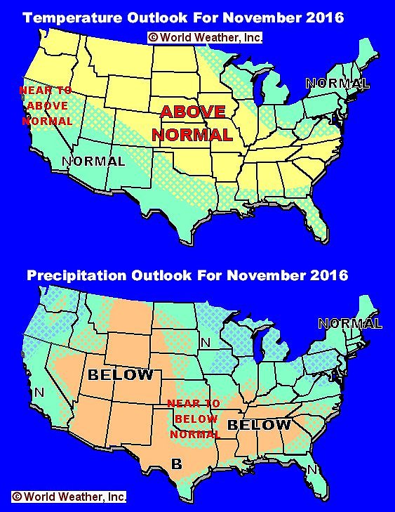 wet month in the eastern half of the nation. Enough cold and warm air mixing will occur to create a few impressive dynamical storms that will produce snow, heavy rain and severe thunderstorms.
World Weather, Inc. believes a more stormy late winter and early spring will occur in the Delta and southeastern states this year with many more outbreaks of severe thunderstorms. Parts of the Ohio River Basin will also be impacted a little later in the spring.
The unusually dry conditions that are prevailing in the Delta and interior southeastern states this autumn looks much like that of La Nina years, but as the winter advances there will be some relief in the region as the stormy pattern evolves. There may still be some dryness along the Gulf of Mexico coast and in Florida over the course of the winter season. Dryness is also expected in a part of the high Plains region and in a large part of the southwestern states.
California’s winter weather will not be terribly bad, but rain and snowfall may be below average for a fair amount of the time. However, World Weather, Inc. believes there will be a couple of periods in which Madden Julian Oscillation (MJO) will bring some significant storminess to the west coast. These events will be few in number, but they will prove to be the saving grace for precipitation in the region this winter. If it was not for these MJO events there would likely be a serious moisture shortage.
The areas most likely to experience warmer biased temperatures for the longest period of time during the heart of winter will be the Great Basin, Pacific Northwest and far western Canada. However, with that said it is very important to note that there will be some bouts of notable coolness in these areas, especially in late autumn and early winter. Once the coldest air reaches into the eastern United States in January and February the western states will likely be warmer biased at times.
World Weather, Inc. forecasts and comments pertaining to present, past and future weather conditions included in this report constitute the corporation’s judgment as of the date of this report and are subject to change without notice. Comments regarding damage or the impact of weather on agricultural and energy as well as comments made regarding the impact of weather on the commodity and financial markets are the explicit opinions of World Weather, Inc. World Weather, Inc. cannot be held responsible for decisions made by users of the Corporation’s information in any business, trade or investment decision.
©2016 World Weather, Inc. Any unauthorized redistribution, duplication or disclosure is prohibited by law and will result in prosecution.