

Ukraine Harvest Delays Linger; CIS Bitter Cold Stays North
By Andrew Owen and Drew Lerner
Kansas City, November 10 (World Weather Inc.) – Summer crop harvesting has come to an end in a large portion of the western Commonwealth of Independent States (CIS). The only areas that have not yet finished the harvest are in portions of Ukraine and neighboring areas in  the USDA defined ‘Southern Region’ of Russia. The corn harvest has been delayed recently in Ukraine where frequent precipitation and cool weather have prevailed. More precipitation and cool weather is expected during the coming week and that will prolong harvest delays in some areas.
In the meantime, portions of Russia have experienced the season’s first bitter cold surge, but snow has been on the ground to protect most of the wheat crop. The cold will soon shift to the southeast raising the need for increased snow cover to protect all winter crops.
Ukraine, Belarus, and neighboring areas through the Ural Mountains region and eastern New Lands reported above average precipitation since the beginning of this month. Moisture totals for the 10-day period ending this morning ranged from 0.50 to 2.00  inches most often with drier pockets. The precipitation often fell as snow and added several inches of accumulation on the ground for many areas. Other sections of the Baltic States and northwestern Russia only received light precipitation. Snow free areas as of November 9 were limited to in Ukraine and Russia’s ‘Southern Region’.
The season’s first bout of widespread bitter cold conditions evolved during the weekend in the snow covered areas of northern Russia. Extreme lows slipped to the range of -30 to -18 Celsius (-22 to 0F) across much of the northern New Lands. The cold had no impact on winter wheat or rye because of the snow cover.
Some of the cold air was expected to shift southwesterly during the coming two weeks and if that occurs as advertised there would be need for a boost in snow cover into Ukraine and southern pa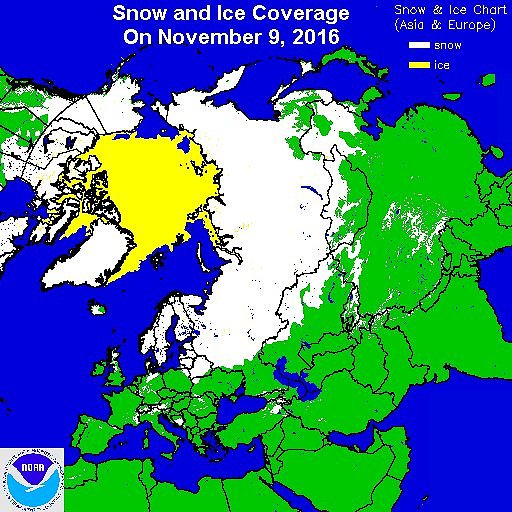 rts of Russia to adequately protect winter grains from possible winterkill. Ukraine is expected to remain in a wet weather pattern over the next couple of weeks and that will likely translate into some eventual snow cover that will help protect crops from the impending cold.
The wetter bias in Ukraine already reported in recent weeks has set back late season fieldwork with corn harvesting just 67% complete versus 84% done at this point in 2015. Dry weather will be needed in the coming weeks for the best late season harvest conditions. But snow is needed to protect winter wheat and rye.
Not much precipitation will occur in Ukraine into Saturday morning, but a strong low pressure center will promote rain and snow across the nation and parts of western Russia this weekend and Monday. Moisture totals will range from 0.50 to 1.50 inches with local amounts over 2.00 inches from western through northern sections of the country. Southern and eastern Ukraine will only receive 0.15 to 0.50 inch of moisture with locally greater amounts. Brief periods of light precipitation will also be possible today and again during the middle and latter part of next week. The frequent occurrence and significance of precipitation coupled with periods of cool weather will limit drying in much of the country. Additional harvest delays are likely. Once snow  accumulates across some of the production region, fieldwork will be on hold until the snow melts and crop areas firm up. That may not happen for a while.
Western Russia and the Volga River Basin will see alternating periods of light precipitation and sunshine through the end of next week. Precipitation will often fall as snow due to colder than normal temperatures in many areas. Moisture totals through next Thursday morning will range from 0.25 to 1.00 inch with locally greater amounts. New snowfall will range from 2 to 7 inches with locally more. The remaining portions of the CIS will only see brief periods of light precipitation during the coming week.
Periods of bitter cold weather will continue in portions of Russia during the next two weeks. The ground will be blanketed by snow and that should maintain a good level of protection for crops against the potential threat of  damage that can occur when temperatures are well below zero Fahrenheit without adequate snow cover.
Many areas in northern and western Ukraine are expecting snow to accumulate this weekend and into Monday and follow up [precipitation a little later in the month will also contribute to the accumulation of snow placing more protection on wheat and rye against the risk of winterkill. However, the wetter bias will restrict late season farming activity.
The recent wet bias has been significant in many southwestern Russia, Belarus and some Ukraine locations. Some of the region reported notably wetter biased conditions in October and during the first ten days of this month. Several areas have received more than five times the normal precipitation and that has left the ground soggy and possibly vulnerable to spring flooding. More importantly the precipitation restricted late season farming activity this late autumn leaving some crops in the fields where they may stay for a while.
World Weather, Inc. forecasts and comments pertaining to present, past and future weather conditions included in this report constitute the corporation’s judgment as of the date of this report and are subject to change without notice. Comments regarding damage or the impact of weather on agricultural and energy as well as comments made regarding the impact of weather on the commodity and financial markets are the explicit opinions of World Weather, Inc. World Weather, Inc. can not be held responsible for decisions made by users of the Corporation’s information in any business, trade or investment decision.
©2016 World Weather, Inc. Any unauthorized redistribution, duplication or disclosure is prohibited by law and will result in prosecution.