

Partial Relief For Canadian Prairies Drought; Rain Still Needed
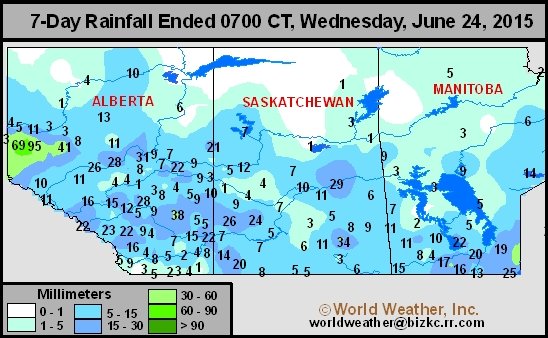
Kansas City, June 26 (World Weather Inc.) – Rain fell in quite a few areas across the Canadian Prairies during the week ending Wednesday, but for much of the region the relief was not enough. The biggest problem with ongoing dryness seems to be in Saskatchewan, but some southernmost Alberta locations and northern Manitoba have not received much rain recently either. Temperatures were seasonable in most of the Prairies over the past week, but a high pressure ridge developing in western parts of the region this weekend into early next week promises to accelerate drying and raise stress in unirrigated areas that have been driest for the longest period of time. Cooling will occur later next week that should also bring the next good chance for rain. Southern portions of the Peace River region in northwestern Alberta’s crop country received significant rain during the past week. Most of the greater rain occurred during the weekend when 0.60 to 3.75 inches resulted. It may have been the single greatest rain event in parts of the region this growing season. Rain also varied across the remaining portions of the Prairies during the past week due to an erratic precipitation pattern. However, the precipitation was not nearly as significant as that in the Peace River region and many areas were only teased by the rain. Moisture totals ranged from 0.15 to 0.80 inch in much of central and southern Alberta with local totals as great as 1.50 inches at Spondin. Saskatchewan rainfall was much less with totals of 0.10 to 0.43 inch occurring most often, but a few totals did come close to 1.00 inch. Indian Head, Saskatchewan reported 1.34 inches of rain while Rosetown and Kindersley reported nearly 1.00 inch. Manitoba rain totals varied from 0.10 to 0.35 inch in the north and 0.15 to 0.75 inch in the south with local totals reaching up near 1.00 inch.
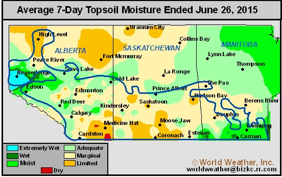
Northwestern Alberta’s crop country has adequate to excessive moisture in the topsoil due to the recent rain. Much of Manitoba is also adequately moist due to timely rain earlier in June and relatively mild temperatures. Soil conditions elsewhere across the Prairies varies tremendously with areas in southern Alberta running very short of moisture along with several areas in southern Saskatchewan. Many other areas have marginally adequate to short topsoil moisture and similar conditions in the subsoil. Canola has been impacted most by extreme weather this year. In addition to the extended dryness that promoted poor development, frost and freezes were noted in several canola areas earlier in the year. The periods of cool weather damaged crops. Canola production will be down and that has already been factored into world commodity prices, but the big question is how well will the crop do the remainder of the growing season? Lentils and other pulse crops were also damaged by late season frost and freezes and erratic rainfall that has often been too light to counter evaporation. Wheat, barley, and other grains have not been nearly as severely impacted by the dryness and late season cold snaps as other crops, but the crops would still benefit greatly by improving weather.
Light and erratic rainfall will evolve across the Prairies through Friday. Much of the rain will not be enough to counter evaporation. A ridge of high pressure will build over Alberta and western Saskatchewan this weekend that will promote mostly dry weather. While Alberta and western Saskatchewan trend mostly dry, scattered showers will continue in eastern Saskatchewan and Manitoba. A few isolated thunderstorms will be possible and could produce more than 0.75 inch of rain. A low pressure center will advance across the Prairies during the first part of next week that will also offer light and erratic rainfall. Temperatures will often trend above average in the Prairies through the middle of next week. This weekend and the beginning of next week will be warmest once the ridge of high pressure is over the Prairies. Daytime highs will be in the 80s and lower 90s Fahrenheit with warmer pockets possible 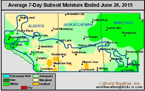 in southern Alberta and southwestern Saskatchewan. Extreme highs may reach into the upper 90s and approach 100 degrees near the Montana border. Temperatures will also trend near to above average through the end of this workweek, but readings will not be as extreme as those expected during the weekend and early part of next week. The warm weather and lack of significant rain will lead to net drying across much of the Prairies during the coming week. Northwestern Alberta and Manitoba are not expected to be adversely impacted by the drying and warming trend because of their more favorable moisture conditions. However, the remaining portions of Alberta and Saskatchewan will trend much drier and crop stress in the driest fields will become significant enough to threaten a new drop in potential production. Timely rain must fall in early July to prevent the stress from becoming a serious factor toward notably lower production. World Weather, Inc. believes rainfall during the first half of July will be erratic once again, but the best news is that temperatures will not be as hot as once suggested and that should help curb some of the stress. However, if rainfall is going to continue erratic there will still be enough stress to pressure yields lower. Many crops will move into reproduction during July and they must have routinely occurring rainfall and seasonable temperatures to yield as well as possible. That will make the month of extreme importance. World Weather, Inc. does not expect the region to be as dry as it was from April into early June, but some areas will continue struggling for improved moisture.