

Brazil Production Boosts Reflect Good Crop Year
By Drew Lerner
Kansas City, February 7 (World Weather Inc.) – Recent production estimates coming out of Brazil have been rising as a reflection of nearly ideal summer crop development this season. Ongoing drought in northeastern Brazil has hurt production  again this year, but almost ideal weather in the remainder of the nation has left the nation poised to yield extremely well. It may not be a record crop, but it will not be far from it. Weather conditions in the past week and that coming up over the next two weeks will only perpetuate the situation.
Rain was widespread in Brazil during the seven-day period ending Monday morning. However, the rain was only heavy in portions of the nation. The greatest rainfall occurred from northeastern Sao Paulo to central Minas Gerais where 2.50 to more than 5.00 inches resulted. Another area of significant rain fell in central Mato Grosso where one location reported over 4.00 inches and that same area received more than 3.00 inches of rain again during the 24 hours ended at dawn today.
 Some significant rain also occurred in southern Paraguay and neighboring areas of western Parana which had been drying down recently. Rain in most other areas during the past week varied greatly, but there were fair-sized regions of net drying. Central Mato Grosso do Sul and areas from northern Rio Grande do Sul to south-central Parana reported some of the lightest rain resulting in a net loss of soil moisture for the week. Portions of Bahia, Espirito Santo, Tocantins and Goias also received an inadequate amount of rain to counter evaporation.
None of the drying this past week was of much concern. The exception to that continued in the northeast where an inadequate amount of rain has occurred since January 1. The past five to six weeks have generated less than half of the usual rainfall from central Minas Gerais and Espirito Santo to  eastern Tocantins and most of Bahia. The drier tendency in the northeast has already been well documented and the drier bias in recent weeks was nothing more than a mere extension of a multi-year drought that was briefly disrupted earlier this summer when significant rain fell. Portions of Bahia, prior to today, reported no more than 16% of the usual amounts of rain since January 1.
Another area that has received less than half of the usual rainfall since January 1 has been in southwestern Mato Grosso do Sul and western Parana. Some of the dryness reached into Paraguay, as well. Absolute dryness is always a problem for crops, but most of Brazil’s drier biased areas outside of the northeast have reported timely rainfall. Brazil normally gets more rain than it needs to support good summer crop  yields and less than usual rain that is favorably distributed through the growing season will nearly always translate into high yields and that is exactly what is happening this year.
Production from Bahia and northern Minas Gerais will be cut, but the region produces not much more than 4% of the total corn and soybean crop. High yields in other parts of the nation have and will continue to counter the losses from northeastern crops areas.
This week’s weather is going to improve the situation in northeastern Brazil for a short period of time. Widespread rain is expected and that will likely bolster topsoil moisture for a little while. However, the rain comes too late for Bahia corn and damage done to soybeans may not be reversible.
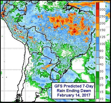 In the meantime, a favorable mix of rain and sunshine will prevail in other areas in the nation. Drying expected in this next seven days in southern Brazil will be followed by a boost in rainfall in the following week and that will maintain the ideal mix of weather needed to support good production and crop quality.
Favorable soil moisture is present today and it will continue through the last days of February. Some harvest delay has occurred this year in Parana, Sao Paulo and Mato Grosso do Sul. Some delay was also noted in Mato Grosso. Fieldwork is notably behind last year’s pace, but last year’s weather was beginning to trend a little drier by this time. The harvest delays noted in recent weeks have not harmed soybeans, but it has delayed the start of Safrinha corn and cotton planting and that may hurt production later in the year when seasonal rains decrease. The sooner crops are harvested the better off the second season crops will be in case seasonal rainfall ends on time or a little earlier than usual. Seasonal rainfall usually ends in late March and April.
The coming week of weather will be ideal in firming up the soil in the previously wettest areas from center west to southern portions of center south Brazil. The drier bias will be perfect in accelerating fieldwork of all kinds, including the harvest of soybeans and the planting of second season crops.
The following week ending Feb. 21 will return wetter biased conditions to southern Brazil and allow the north to dry down once again. This reversal in this coming week’s rainfall pattern will be in line with previous weeks of well mixed weather seeing to it that no area becomes excessively wet or dry (excepting the northeast, of course). These conditions will only reinforce the nearly ideal crop development environment that has been present for much of the growing season.
World Weather, Inc. forecasts and comments pertaining to present, past and future weather conditions included in this report constitute the corporation’s judgment as of the date of this report and are subject to change without notice. Comments regarding damage or the impact of weather on agricultural and energy as well as comments made regarding the impact of weather on the commodity and financial markets are the explicit opinions of World Weather, Inc. World Weather, Inc. cannot be held responsible for decisions made by users of the Corporation’s information in any business, trade or investment decision.
©2017 World Weather, Inc. Any unauthorized redistribution, duplication or disclosure is prohibited by law and will result in prosecution.