

Western Pacific Breeds Three Tropical Cyclones; Watch China
By Drew Lerner
Kansas City, July 6 (World Weather Inc.) – Instability in the atmosphere and warm ocean temperatures have come together to create three tropical cyclones since late last week. The first, named Linfa, moved across Luzon Island, Philippines during the weekend producing heavy rain and further easing long term dryness that plagued the region earlier this year. The second storm is the one that most of southeastern China and Taiwan will be on high alert for later this week. This second storm, named Chan-Hom, is already a typhoon and has tremendous potential to become the largest and most potentially damaging storm of the year and it is expected to move close to Taiwan and southeastern China by the end of this week. The third tropical cyclone was named Nangka and it is far enough from land this week that it presents little threat, but that could change next week as it moves toward Japan. Tropical Storm Linfa moved across northern Luzon Island, Philippines during the weekend producing some heavy rain. The storm was located to the west northwest of Luzon Island at 1500 GMT today. The center of the storm was 321 miles north northwest of Manila at 19.9 north, 119.3 east. Movement was northerly at 6 mph and was producing a maximum sustained wind speed of 46 mph with gusts to 58 mph. 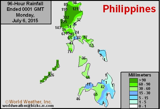 Linfa produced 1.00 to 3.50 inches of rain across the southern half of Luzon Island during the weekend while amounts in the north ranged from as little as 1.50 inches along the central coast to between 4.00 and 13.00 inches in the interior north and west-central parts of the island. Flooding was already reported in parts of the island and rain was still falling in some western areas today. The western rainfall may continue in Luzon for the next two to three days until the system’s circulation changes the surface wind flow across the region. A westerly wind blowing around the tropical storm will send warm moist air up against the mountains in Luzon Island. The air will move upslope and cooling is expected as the air is lifted higher into the mountains and that cooling will cause condensation and result in additional significant rainfall. Flood conditions may continue over the next few days even though the storm center becomes further removed from the region. Additional rain totals of 5.00 to 10.00 inches will occur by Wednesday. Linfa is expected to dissipate as a tropical cyclone west of Taiwan and immediately south of the eastern Guangdong, China coast. World Weather, Inc. believes the system may hold together longer than the Joint Typhoon Warning Center has suggested and that will result in very heavy rain in parts of Guangdong during the second half of this workweek. Flooding might cause a few problems in crop areas and to the region’s infrastructure, but no long term impact is expected on rice, sugarcane, groundnuts or other crops produced in the region. Rain totals from the storm may range from 3.00 to 6.00 inches with local totals to 10.00 inches.
  In the meantime, the storm of the season will be Chan-Hom. Its center at 1500 GMT today was located near 18.1 north, 138.9 east or 825 miles southeast of Okinawa. The storm was moving west northwesterly at 16 mph and maximum sustained wind speeds were already reaching 75 mph and the storm has potential to generate wind speeds twice as great (nearing 150 mph) by late Wednesday or early Thursday. Chan-Hom is expected to move toward Zhejiang or northeastern Fujian, China this week with landfall possible Friday or Saturday. World Weather, Inc. believes the storm may move a little more west than northwest and that would likely take the storm across Taiwan to southeastern China. The system must be closely monitored because of is predicted intensity and possible impact on agriculture and personal property. There is still plenty of time for the storm to veer from the predicted paths and until it gets closer to land confidence will remain low. The storm will have potential to produce 3.00 to 9.00 inches of rain with local totals of more than 12.00 inches and if the storm hits Taiwan there would be potential for more than 20.00 inches of rain. Flooding will be extensive with much damage likely. Wind speeds could be horrific at the time of landfall, as well and the system needs to be closely monitored. Typhoon Chan-Hom will have an indirect influence on parts of the North China Plain this week by drying out the region and heating it up. Temperatures will rise through the 90s Fahrenheit and likely breach 100 degrees ahead of landfall. Most of the North China Plain will also experience accelerated drying throughout the workweek because of the approaching storm.