

California Should Brace For Tough Winter
By Drew Lerner
Kansas City, September 2 (World Weather Inc.) – The “Godzilla” of El Nino events? Really? You have to hand it to the media they really know how to get your attention and perhaps this meteorologist has learned a thing or two from the media with the headline for this special writing, but the attention of disaster management teams in California needs to be obtained as well as residents of California that are unfamiliar with how bad the weather can get in certain circumstances. California stands to receive badly needed improvements in water supply to head off a serious disaster with water shortages, but it will not take long in the first quarter of 2016 for people to realize that the way nature is going about the relief is a little overwhelming and some serious damage to personal property, agriculture and infrastructure is possible.
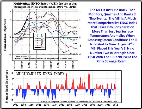
First clarity is necessary. Yes, the El Nino event under way is expected to reach the same intensity or slightly more than the El Nino event of 1997-98. That El Nino holds the record for the greatest ocean surface temperature anomalies in the eastern equatorial Pacific Ocean since records began. That sounds amazingly ominous and when the media talks about the “Godzilla of El Nino events” it is referring to this fact of record proportions in the intensity of El Nino. You need to understand first that we only have “good” records for El Nino since 1950. There are a number of database services that have created El Nino data back well into history, but you must know that some of that data is just simply manufactured from what little we scientists know about the phenomenon. There is not enough actual weather and ocean data to verify the magnitude of El Nino and La Nina events that occurred prior to 1950. That suggests that this year’s El Nino may not be the strongest event in absolute history, but it certainly is going to be in the top two since 1950.
The second most important fact that our readers must know is that the intensity of each El Nino event is not directly correlated with the amount of adversity that comes from these events. You cannot take the potential record intensity of this El Nino and conclude that it will have a record impact on world agriculture and economies. This is obvious in the behavior of this year’s El Nino, thus far.
How Significant Has This El Nino Been On the World?
Up through early August, El Nino was ranked the second strongest El Nino on record behind that of 1997-98. It is projected to eventually be as strong as or stronger than the 1997-98 event. The media implication is that death and destruction associated with El Nino will be far worse than any other event and that is totally wrong. So far this year’s El Nino has not hurt Australia’s winter crop production at all and most of Australia’s wheat, barley and canola are still rated in good shape – many times better than in past El Nino events both strong and weak. India is another place that normally has a terrible impact from El Nino events and has – so far – seen much less severity than some of the weaker El Nino events of the past.
Up until recently the impact on Indonesia and Malaysia has not been nearly as severe as in the past, but admittedly that is quickly changing and drought is beginning to take a toll on Indonesia and this will prevail over the next few weeks. Malaysia, however, has not seen nearly as much dryness.
Philippines weather was critically dry in the first several months of this calendar year, but conditions have improved in recent weeks. Although not normal, the nation is in much better shape now than earlier in the year.
Mainland areas of Southeast Asia, Central America and Central Africa have all reported less than usual rainfall – which is typical of El Nino events, but the degree of damage on crops has not necessarily surpassed that of other El Nino events.
And lastly, the drought in Europe cannot be attributed to El Nino because past El Nino events have produced slightly wetter biases and mild temperatures not hot and dry conditions like those of this year.
There is no doubt that this year’s El Nino has influenced the world and there is no doubt that it will continue to do so for several more months. Some areas, like Indonesia and California are bracing for greater influence in the months that lie ahead. In the case of Indonesia, drought conditions may worsen into the fourth quarter of this calendar year before improving in early 2016. In the case of California conditions will be at their worst in the first quarter of 2016.
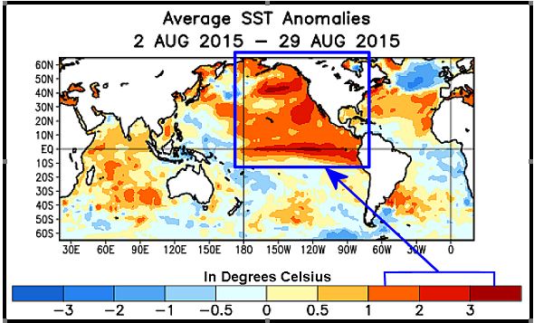
California’s potential problems are not going to be solely an El Nino event. Two other features will play into the development of frequent strong storm systems moving across the U.S. Pacific Coast and into the Rocky Mountains. The first and most important feature is the huge amount of ocean surface that is warmer than usual in the Pacific Ocean. It is not just the equatorial region of the Pacific Ocean that is warm. Virtually all areas east of the International Dateline from the Gulf of Alaska to the equator and east to the North and Central America Coasts are notably warmer than usual.
Scientific Reason Why Warm Ocean Water Matters To California
Why is the warm ocean water such a big deal? Step inside your kitchen and put a pot of water on the stove. Do not turn the heat on initially and put your hand over the top of the pot of water. The bottom of your hand should feel no different than the top of your hand. Now turn the heat on the pot of water and let it warm up a bit. Then put your hand back over to top of the pot of water again. You should note within a short amount of time that the bottom of your hand is warming and getting all sweaty. The moisture is coming from the pot of water. As the water warms the water molecules get excited and want to get away from the heat and some of them literally jump out of the pot and become suspended in the air above the water. The air above the pot of water warms as more of the water droplets escape the pot of water. These minute water droplets are called water vapor and you might know it as steam. As the air above the pot of water continues to warm the air begins to rise because warm air becomes less dense and as it becomes less dense it rises – just like a hot air balloon.
The same process impacting your kitchen and the pot of water occurs over an ocean body in which the water temperature is increased. The water vapor that is introduced into the atmosphere from the pot of water or ocean can be carried great distances by the wind and sometimes and be lifted high into the air. The bottom line is that as the ocean trends warmer the amount of moisture that gets introduced into the air becomes much greater.
During the winter season the mid-latitude region of the Pacific Ocean is frequently impacted by large surges of cold air sweeping southward from the polar region. In a normal winter the cold air masses will blow across the ocean and pick up some water vapor and the contrast in air mass temperatures can result in the development of deep (strong) low pressure systems aloft. The amount of rain and snow that falls from these storm systems is directly correlated with the amount of water vapor available and the amount of contrast there is in airmass temperatures.
Applying The Science To Winter 2015-16
This year’s warm Pacific Ocean sets the stage for huge volumes of water vapor to be lifted into the atmosphere and the broad region of warm ocean water will allow the water vapor to be lifted high into the atmosphere, as well. This year’s wintertime cold surges that move across the eastern Pacific Ocean will develop and grow into huge low pressure systems in response to the vast amount of water vapor that will be suspended in the atmosphere and the greater contrast in air temperatures that will evolve as the cold surges move over the warm ocean water.
The situation evolving for this autumn and winter will be ideal for numerous large storm systems to evolve across the eastern Pacific Ocean before moving into the west coast of the United States. The already enhanced storm systems will then get one more lift when the air flows across the water and into the mountains of California and sometimes the Pacific Northwest. A west or southwesterly wind blowing ahead of a storm system approaching California will be forced to rise high up into the atmosphere when the wind blows into the Sierra Nevada. The extra lifting of the warm, moist, air up the western slopes of the California mountains will induce greater cooling and huge amounts of water (rain and snow) will then be squeezed out of the atmosphere as these warm and moist air masses condense in the colder air in the higher altitudes
This year’s prevailing winter weather pattern will bring a more active jet stream than usual into the California coast during January, February and early March. During those two and a half months there will likely be frequent storms of significant size that “may” produce copious amounts of rain. A few storms of lesser intensity will come in November and December, but pattern will become very active during the January through early March period at which time flooding is expected.
Many of the strong Pacific storms that reach California will produce strong winds, rough seas and copious amounts of rain and mountain snow. It might not take long to change the celebrations over welcome rain in California into worry over how to avoid damaging floods. Mudslides may occur in portions of southern California and flooding could become serious enough in some communities to bring damage to homes and businesses as well as infrastructure. All of this assumes conditions will be similar to those of 1997-98. The parallel looks significant today, but much can change by the end of this year and the situation needs to be closely monitored.
It has been many years since the U.S. west coast has been pounded by intense storm systems, but this record or near-record El Nino event and all of the warmth in the eastern Pacific Ocean will not bode well for California if there are any significant cold surges of air that come to the coast and our Trend Model is predicting frequent cold surges into the region during the first quarter of 2016.
Madden Julian Oscillation (MJO) events can further enhance this entire scenario. MJO events produce greater uplift into the atmosphere and when these events occur over warmer than usual ocean water in the middle of winter the dynamics become even more intense producing some very dangerous storms. Quite often MJO events are minimized when strong El Nino events are under way. However, as El Nino weakens this coming winter MJO events should begin to occur more often and that will further raise the potential for damaging weather along the U.S. Pacific Coast.
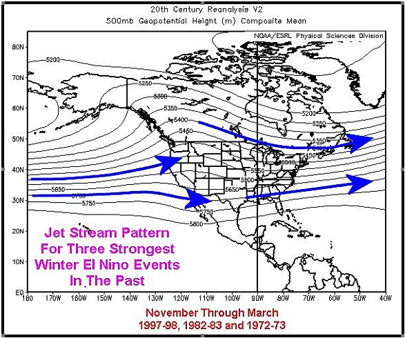
High pressure usually prevails aloft over British Columbia and parts of the U.S. Pacific Northwest in El Nino events. That tends to push the jet stream a little further to the south resulting in California and southern coastal areas of Oregon to feel the brunt of storms resulting from warm ocean water in the Pacific, as well as El Nino and MJO events.
The 1997-98 El Nino event operated under some of the same conditions that are present today and as long as there are no serious changes to El Nino or Pacific Ocean temperatures in the next few weeks the odds are high that California could be inundated by several very large rain and snow producing storms with a few bouts of intense wind and flooding, as well.
To put it in better perspective California had a record wet year in 1997-98. During the October through February period the state averaged 26.46 inches of rain which was 10.96 inches above average. The normal rainfall for the five month period is 15.50 inches. February was the stormiest month with rainfall surpluses rising from 3.31 inches from October through December to 10.76 inches in the October through February period. Flooding and structural damage came with several of the storms and a few brought excessive wind and coastal flooding for exceptional high tides and waves with the more powerful storms.
There is no guarantee that weather this winter will be as severe as described, but no one should turn their back on the situation and assume it will be just a wet winter favoring improved water supply. The water supply should improve, but it may come with some very nasty side effects and Californians, government officials and emergency management organizations should begin preparing now for the “possibility” for damaging conditions.
World Weather, Inc. forecasts and comments pertaining to present, past and future weather conditions included in this report constitute the corporation’s judgment as of the date of this report and are subject to change without notice. Comments regarding damage or the impact of weather on agricultural and energy as well as comments made regarding the impact of weather on the commodity and financial markets are the explicit opinions of World Weather, Inc. World Weather, Inc. cannot be held responsible for decisions made by users of the Corporation’s information in any business, trade or investment decision.
©2015 World Weather, Inc. Any unauthorized redistribution, duplication or disclosure is prohibited by law and will result in prosecution.