

Parts of Mexico Still Getting Rain Long After Hurricane
By Andrew Owen
Kansas City, November 2 (World Weather Inc.) – Portions of Mexico have been receiving more than the usual amount of rainfall long after Hurricane Patricia brought its heavy rain and flooding ashore in Jalisco October 24. Another tropical disturbance fed moisture across a part of the region late last week and that, just like Patricia, fed moisture across Texas to contribute to more flooding rainfall this past weekend. The Texas rain has been well publicized, but portions of central through northeastern Mexico have also been wetter than usual and the trend is expected to finally break down this week.
Crop areas in Mexico from near Jalisco and Nayarit were impacted by Hurricane Patricia and the tropical disturbance that brought more rain to the region last week. The greatest rainfall during the seven day period ending last Friday occurred in Jalisco and immediate neighboring areas in coastal Michoacán where rain totals ranged from 3.00 to 8.00 inches most often with locally greater amounts. Other sections of Mexico outside the northwestern production region reported 0.40 to 1.65 inches of rain with locally greater amounts. Northwestern Mexico was mostly dry and remained that way during the weekend.
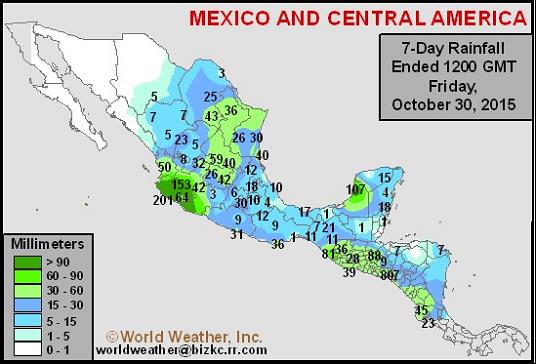
The two tropical weather systems had an impact on soil moisture and induced some flooding, but the biggest impact of Patricia on agriculture was apparently to about 5,000 acres of Banana trees that were knocked down in Jalisco.
Jalisco and neighboring areas are excessively wet due to the rainfall from Hurricane Patricia and the follow up weather system last week. Topsoil moisture is rated adequate in most areas outside of northwestern Mexico due to periodic rain in recent weeks. Pockets of dryness recently began to pop up in Guerrero, where little rain was reported during the past week. Northwestern Mexico has short or very short soil moisture, which is normal for this time of year.
One of the main concerns for Mexico stemming from Hurricane Patricia was corn and sugarcane production from Jalisco and neighboring areas. Jalisco produces 21% of the nation’s corn while the region produces approximately 17% of the sugarcane. The combination of heavy rain and strong wind speeds promoted damage to several crops and structures. Some of the corn may have already been harvested, but sugarcane harvesting occurs later in the year and it may have been more seriously damaged. Corn that had not been harvested was likely lodged and rendered unharvestable except by hand. Coastal locations of Jalisco likely saw the greatest amount of crop damage. Sustained wind speeds were at 200 mph when Patricia made landfall. Gusts were approaching 250 mph. Such wind speeds destroy everything in its path. .
Coffee and the other sugarcane areas were not severely impacted as Hurricane Patricia moved over Mexico. The disturbance rapidly weakened over the Sierra Madre Mountain Range and left only brief periods of light rain in central Mexico. The region had been a little too wet earlier in October to promote the best harvest and general fieldwork conditions. Periods of drying did occur in the most recent week that helped improve the harvest.

Winter corn and sorghum planting will gradually evolve in the coming weeks. Areas recently impacted by heavy rain will likely see a good environment for planting and establishment once the ground firms up. Other production regions should see aggressive planting in the next few weeks as long as timely precipitation occurs.
Alternating periods of rain and sunshine will evolve in central and northeastern Mexico during the next seven to ten days. The rain will either help bolster soil moisture to adequate levels or will help to keep maintain soil moisture at adequate levels.
Scattered shower activity will occur on a frequent basis in southern Mexico during the coming ten days while northwestern Mexico remains in a dry mode. Summer sorghum and corn harvesting may be slowed at times due to the rain, though there will be ample time between rain events to get into the fields. Winter wheat and sorghum planting should advance swiftly around the rain events.
World Weather, Inc. forecasts and comments pertaining to present, past and future weather conditions included in this report constitute the corporation’s judgment as of the date of this report and are subject to change without notice. Comments regarding damage or the impact of weather on agricultural and energy as well as comments made regarding the impact of weather on the commodity and financial markets are the explicit opinions of World Weather, Inc. World Weather, Inc. can not be held responsible for decisions made by users of the Corporation’s information in any business, trade or investment decision.
©2015 World Weather, Inc. Any unauthorized redistribution, duplication or disclosure is prohibited by law and will result in prosecution.