

Central U.S. Storm Leaves Behind Deep Snow, Flooding Rain
By Drew Lerner
Kansas City, November 18 (World Weather Inc.) – Tuesday’s storm in the central United States left behind significant snowfall in the northwestern U.S. hard red winter wheat country and flood conditions in a part of the region from eastern Texas and the Delta into Missouri and  Illinois. Much improved weather will occur today as the storm shifts east and north out of the Midwest.
A complex storm system impacted the central United States Tuesday and it produced significant rain and snowfall along with strong wind just as it was advertised to by the U.S. GFS computer forecast model earlier this week. Rain totals from eastern Texas, Louisiana and Mississippi northward to Illinois and Missouri range from 1.00 to more than 4.00 inches. Several counties in eastern Texas, eastern Louisiana and a few in southeastern Arkansas and central Missouri received 4.00 to more than 5.00 inches of rain resulting in flood conditions. Most of Illinois reported rainfall of 1.00 to 2.00 inches and the same was true for northwestern Missouri.
Further to the west in hard red winter wheat country a significant band of heavy, wet, snow fell from northwestern Kansas to central Nebraska and some of the area also reported rain  and a little freezing rain. Snowfall of 4 to 10 inches occurred across parts of the region, but the Colby/Atwood, Kansas area reported upwards to 20 inches causing road closures and several stress to livestock.
Wind speeds in the west-central Plains were suspected at 20 to 30 mph most of the day Tuesday with gusts reaching up to more than 50 mph. Boulder, Colorado reporting wind gusts to 80 mph. The wind and snow caused white-out conditions and halted travel across the region. Some road closures occurred in northwestern Kansas.
Livestock stress was also severe in the northwest Part of Kansas and poor in western Nebraska and eastern Colorado, as well, although most of Colorado’s adverse weather occurred Monday night into Tuesday morning.
Reports of hail were received from some of the Arkansas, eastern Texas and Louisiana crop areas and reports of tornadic damage were received in parts of Mississippi.
The storm will storm system was weakening this morning while continuing to move east and north through the U.S. Midwest and interior southeastern states. Rain was falling most significantly from eastern Mississippi and extreme western Alabama into western and 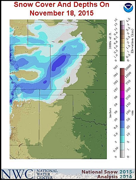 southern Indiana while snow was winding down from central Kansas into central Nebraska. Lighter rain was occurring from Minnesota and Wisconsin into northern Illinois and northwestern Indiana. Rainfall of 1.00 to 2.50 inches and locally more will occur today from Alabama to Kentucky and a part of the southern Appalachian Mountain region. Lighter rain and snow will occur across the upper Midwest.
Most of the upper Midwest precipitation will occur as rain today, but it will change to snow briefly tonight as colder air moves into the region tonight and prevails Thursday morning. Most of the snow will occur from the eastern Dakotas to northern Minnesota and northern Wisconsin and accumulations will be light.
World Weather, Inc. forecasts and comments pertaining to present, past and future weather conditions included in this report constitute the corporation’s judgment as of the date of this report and are subject to change without notice. Comments regarding damage or the impact of weather on agricultural and energy as well as comments made regarding the impact of weather on the commodity and financial markets are the explicit opinions of World Weather, Inc. World Weather, Inc. cannot be held responsible for decisions made by users of the Corporation’s information in any business, trade or investment decision.
©2015 World Weather, Inc. Any unauthorized redistribution, duplication or disclosure is prohibited by law and will result in prosecution.