

Northeastern Brazil Drought Will Be Further Eased
By Andrew Owen and Drew Lerner
 Kansas City, November 15 (World Weather Inc.) – Scattered showers and thunderstorms brought needed relief to a multi-year drought in northeastern portions of Brazil during the past week and the wet pattern will last for another two weeks offering a further bolstering of soil moisture and could lead to flooding in some areas in the wetter biased areas. Fieldwork will advance slowly until the ground has a chance to firm. Crop growth and development will, otherwise, be favorable. In the meantime, rainfall in portions of center-south and far southern Brazil will drop below average in the next two weeks. Warm weather and limited rainfall will lead to some aggressive drying in a portion of the region raising the need for timely rain later this month and in December to maintain the best possible production potentials. Drying in the south will initially be welcome following recent moisture abundance.
Areas from Sao Paulo, Minas Gerais and Bahia through Goias  to much of Mato Grosso and Tocantins received significant rain during the past week. Moisture totals for the seven-day period ending this morning surpassed 4.00 inches in eastern Mato Grosso, east-central and southeastern Minas Gerais, Rio de Janeiro and random locations in western Minas Gerais and central Goias. Franca, Sao Paulo reported 5.90 inches, but the greatest rain occurred in Rio de Janeiro northward to east-central Minas Gerais where 4.00 to 10.78 inches resulted and some flooding evolved. Rainfall elsewhere in the described region was not quite so excessive with 1.00 to 3.00 inches common.
Rain was much lighter in far western Mato Grosso through much of Mato Grosso do Sul, western and southern Parana to parts of Rio Grande do Sul where rainfall varied from 0.30 to 0.84 inch where net drying occurred. Several local totals of 1.00 to 1.81 inches occurred across central Rio Grande do Sul.
 The ground is saturated from southern Minas Gerais and neighboring areas through Mato Grosso due to the recent rainfall. Fieldwork has likely become sluggish and flooding was suspected in southeastern Minas Gerais and Rio de Janeiro. Topsoil moisture elsewhere is mostly adequate. The recent increase in rain across northeastern Brazil has restored favorable topsoil moisture to many areas, but subsoil moisture is still very low and water supply is still dismally low implying the need of many more weeks of rain to end drought. Farmers would prefer that the additional rain be spread out over time and not come all at once for fear of more damage to crops.
Corn, soybean, rice, and other summer crops were planted and established under mostly favorable conditions in recent weeks. The lack of significant rain in southern Brazil was beneficial for more aggressive fieldwork after rain delays earlier this season. The boost in 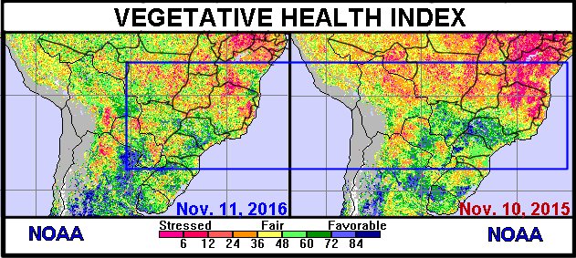 rain in northeastern Brazil, Goias and Mato Grosso will significantly improve production potentials this year if there is favorable follow up rain through the summer – as is expected.
Winter wheat harvesting advanced well around rainfall in Rio Grande do Sul. The rain was not enough to significantly delay fieldwork or have much of an impact on wheat quality, but the quality has already been seriously reduced from torrential October rainfall. Dry weather is still needed in far southern Brazil to bring wheat harvesting to a conclusion.
Rain will continue to fall on a near daily basis from Minas 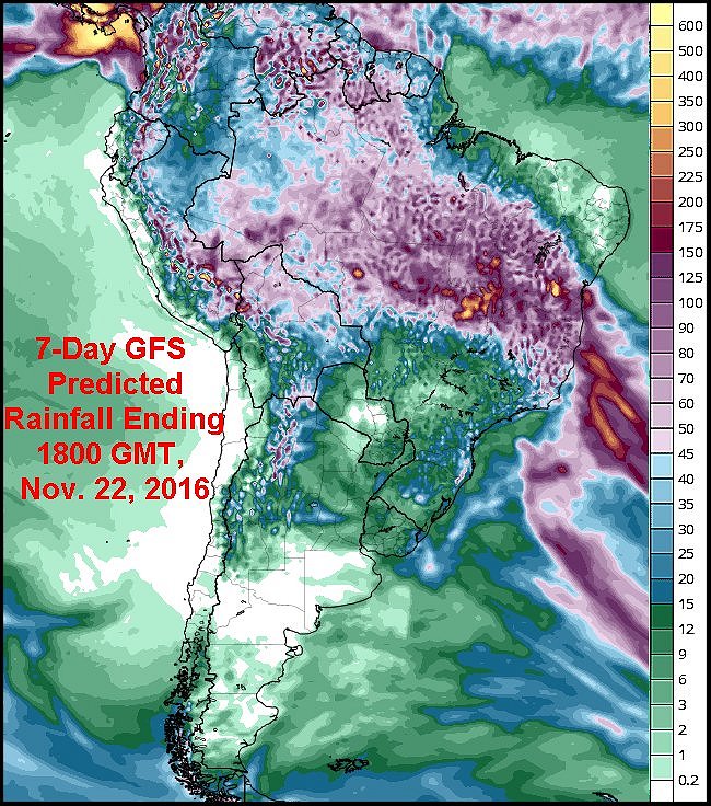 Gerais and Bahia through Mato Grosso this week. Moisture totals through Monday will range from 1.00 to 5.00 inches with locally greater amounts. The additional rain will further bolster soil moisture and help break the drought in northern Minas Gerais, Tocantins, Espirito Santo, Bahia and northeastern Goias. However, flooding will be possible in several areas and could significantly delay fieldwork. Minor crop damage will be possible in the wetter-biased areas if severe flooding evolves which is unlikely. Frequent rain November 22 – 28 will maintain the wet conditions and assure significant runoff into the region’s river and streams to help fill some of the water storage facilities. A break in the rain will be needed to prevent a serious flood event from evolving. Rain intensity is not expected to be as great in the coming week as it was in recent days and that will help reduce the threat of serious flooding.
Southern portions of center-south and far southern Brazil will only see periods of light rain this week. Much of the rain that falls will be too light to counter evaporation or impact long-term soil conditions. The ground will gradually firm and could become too dry to support the best corn, soybean, and rice growth conditions in time, especially in Mato Gross do Sul, western Sao Paulo, northern Parana and a part of southern Paraguay where the least rainfall is expected in this coming week.
Winter wheat harvesting will advance swiftly around the rain events.
World Weather, Inc. forecasts and comments pertaining to present, past and future weather conditions included in this report constitute the corporation’s judgment as of the date of this report and are subject to change without notice. Comments regarding damage or the impact of weather on agricultural and energy as well as comments made regarding the impact of weather on the commodity and financial markets are the explicit opinions of World Weather, Inc. World Weather, Inc. can not be held responsible for decisions made by users of the Corporation’s information in any business, trade or investment decision.
©2016 World Weather, Inc. Any unauthorized redistribution, duplication or disclosure is prohibited by law and will result in prosecution.