

Timely Precipitation Slated For California
By Andrew Owen
Kansas City, March 3 (World Weather Inc.) – After a drier than normal bias in much of California in February, timely precipitation will return to portions of the state during the next seven days. The greatest amount of precipitation will evolve over the weekend and into the 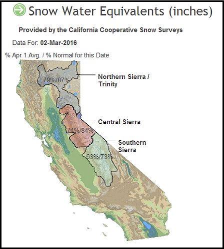 beginning of next week. Precipitation totals will be high enough to bolster mountain snowpack and improve soil conditions in a few locations. Other bouts of rain and mountain snow will still be required to raise water storage levels as high as possible before the wet season ends. In the meantime, the U.S. Pacific Northwest was also generally drier than normal in February, but snowpack in the mountains is still in mostly good shape due to the timely precipitation earlier in the winter.
No major snowpack increases were noted for California in recent weeks due to the lack of precipitation and periods of warm weather. Snow-water equivalents for this time of year are 73% to 87% of normal in the Sierra Nevada down from near to slightly above average in late January and early February. Snow-water equivalencies relative to the April 1 average were 63% to 79% of normal leaving plenty of room for improved snowpack before the wet season ends. California needs its mountain snow water equivalents to be well above average to significantly bolster water reservoir levels across the state and to reduce water restrictions and the fear or worsening drought.
Soil moisture remains short or very short in southern California and some of the central Valleys. The moisture profile is much better in northern California than in the south. Reservoir levels remain lower than historical averages in much 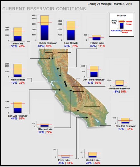 of the state with Folsom Lake Reservoir one of a few that has water levels back to near normal.
The spring runoff outlook for California and general water supply is looking better for this year than in 2015, but improved precipitation will be needed in March and April to assure that this trend continues. Snowpack is much greater this year than last year at this time and water reservoir levels are higher, but after multiple years of drought the region needs much more precipitation to bring water supply back to normal. Drought conditions have not ended and most areas will require another year or two or improved precipitation before such a declaration can be made. Precipitation is also needed to bolster soil moisture and improve planting prospects in much of the state.
Soil temperatures are warm enough for planting to have already begun in many areas. However, many producers may wait until later in March to put much crop in the ground.
A band of scattered showers will produce light precipitation in portions of northern and central California Friday. Precipitation will increase greatly over the weekend and beginning of next week when a strong Pacific weather disturbance and reinforcing shot of cold air drift across the U.S. west coast. Dry weather will return Wednesday through the end of next week, although another storm system could produce additional precipitation in California March 12 – 13.
 Mountain snowpack will increase substantially across the Sierra Nevada by the middle of next week. Short-term soil conditions will also improve in portions of California’s central Valleys. Early season planting may advance swiftly in the next few days before the significant precipitation event begins.
Moisture totals in the Sierra Nevada will vary from 2.00 to 4.00 inches with local totals over 6.00 inches during the Friday through Tuesday period. Rain in the central valleys will range from 0.75 to 1.50 inches with some of the eastern foothills receiving upwards to 2.00 inches. Coastal areas in California will receive 1.00 to 3.00 inches of rain with a few heavier amounts in the north.
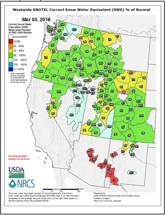
In the meantime, snow-water equivalents in the Pacific Northwest are in good shape relative to normal. Most areas have near to slightly above average snowpack for this time of year, despite the lack of precipitation in the past weeks. Soil conditions are still rated favorably, despite El Nino. There are a few pockets in southern Washington and central Oregon that have a minor shortage of moisture and could use a boost in precipitation. Winter wheat growth and spring crop planting conditions will get off to a good start this year once the ground warms enough to support crop development.
Several weather disturbances over the Pacific Ocean will slam into the U.S. Pacific Northwest during the next two weeks. These disturbances will produce enough precipitation to lift snowpack and improve soil moisture in most locations.
Not all of the western United States has been benefiting from precipitation this winter. A few mountain ranges east of the Continental Divide are running a little low on mountain snowpack and spring runoff potentials. The most significant dryness issue is in the southwestern states where precipitation has been minimal recently. Some mountains in Arizona and New Mexico are reporting 7-41% of normal snow water equivalencies and precipitation in the region has been minimal so far this rainy season.
The southwestern U.S. may continue struggling with dryness for a few more weeks. California’s storminess this weekend and next week will only spur on one storm system for the southwestern states and it is likely to diminish as it moves through the region. No follow up storm system is expected prior to mid-March. Much of the southwestern U.S. crop country is irrigated, but greater rainfall must occur soon to help bolster soil moisture and water supply back to normal.
World Weather, Inc. forecasts and comments pertaining to present, past and future weather conditions included in this report constitute the corporation’s judgment as of the date of this report and are subject to change without notice. Comments regarding damage or the impact of weather on agricultural and energy as well as comments made regarding the impact of weather on the commodity and financial markets are the explicit opinions of World Weather, Inc. World Weather, Inc. can not be held responsible for decisions made by users of the Corporation’s information in any business, trade or investment decision.
©2016 World Weather, Inc. Any unauthorized redistribution, duplication or disclosure is prohibited by law and will result in prosecution.